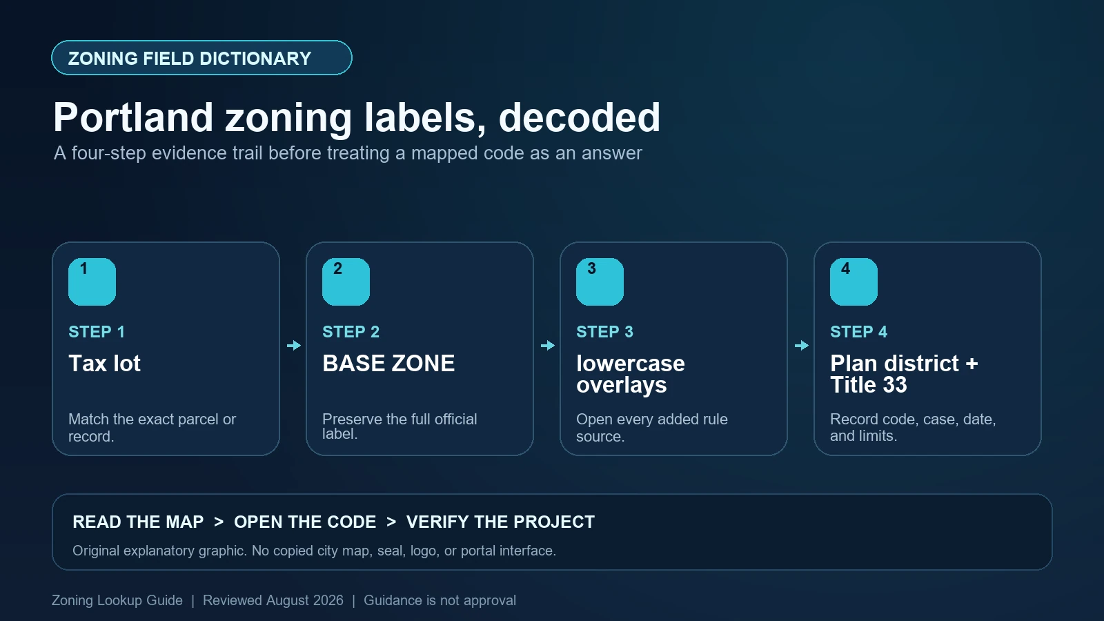
Portland uses typography as part of the zoning record. A base zone appears in capital letters and numbers, such as R5, RM1, CM3, or IG2. Lowercase letters appended to it identify overlays, so R5s means an R5 base zone with the scenic-resource s overlay. A parenthetical value has a different role: R5 (R2.5) records current R5 zoning beside an R2.5 Comprehensive Plan map designation. Plan districts, historic districts, and conservation districts are mapped boundaries that must be recorded in addition to the compact symbol.
Last checked: August 7, 2026.
The City explains this notation on its official Zoning Maps and Regulations page. Use PortlandMaps by address or intersection, a tax-lot search, or the official quarter-section map. Then open every matching Title 33 chapter. The symbol is a routing key; it is not a land-use review, adjustment, permit, nonconforming-status decision, or assurance that a proposed building is allowed.
Match the search result to the tax lot and project area
PortlandMaps can find an address or intersection, and the City also provides a tax-number search. Save the property ID or tax-lot reference, selected outline, quarter-section map number, and exact location of the proposed work. If development covers several lots, inspect each. A street address can navigate to a building while an overlay or district boundary clips a different portion of the tax lot.
At a boundary, compare the interactive result with the official zoning map and a reliable survey or legal description. Annotation arrows and labels are cartographic aids, not substitute boundaries. When a line is too close to call, ask Portland Permitting & Development for the appropriate zoning confirmation. Do not estimate the controlling zone from the center of a parcel or from the color covering most of it.
Capital letters and numbers identify the current base zone
The City’s current Base Zones page lists the codes used for its residential, commercial or mixed-use, employment and industrial, and campus institutional categories. Examples include RF, R20, R10, R7, R5, and R2.5 for single-dwelling areas; RM1, RM2, RM3, RM4, RX, and RMP for multi-dwelling areas; CR, CM1, CM2, CM3, CE, and CX for commercial or mixed-use areas; EG1, EG2, EX, IG1, IG2, and IH for employment or industrial areas; and IR, CI1, and CI2 for campus institutional areas.
Copy the symbol exactly, including decimals. Similar-looking zones can have different allowed uses, density, floor-area ratio, height, setbacks, or form standards. Use the base-zone chapter in Title 33 and the current use and development tables. Do not translate R2.5 into a lot-size promise, or CM3 into a blanket permission for every commercial activity, without reading definitions, footnotes, and site-specific constraints.
| Map notation | Correct reading | Common misreading |
|---|---|---|
| R5, RM1, CM3, IG2 | Current base zone in capital letters and numbers | A complete statement of all applicable regulations |
| R5s | R5 base zone plus lowercase scenic-resource overlay | A distinct base zone named R5S |
| R5 (R2.5) | Current R5 zoning plus R2.5 Comprehensive Plan designation | Two current zones applying at the same time |
| c or p | Environmental Conservation or Environmental Protection overlay | Generic environmental information with no Title 33 consequence |
| Plan district name | A separately bounded district with its own Title 33 chapter | A suffix that can be ignored if absent from the compact symbol |
| Historic or conservation boundary | A mapped designation requiring separate standards and review research | The same thing as a scenic-resource s overlay |
Lowercase letters are overlays, and each letter has its own subject
Portland’s current Overlay Zones page identifies b for Buffer, d for Design, c or p for Environmental, f for Future Urban, g* or e for River, g, i, n, q, or r for Greenway, h for Aircraft Landing, k for Prime Industrial, m for Centers Main Street, s for Scenic Resource, v for Pleasant Valley Natural Resources, x for Portland International Airport Noise Impact, and z for Constrained Sites. It separately describes the Historic Resource Protection overlay as not displayed on the maps. Record every lowercase letter in the sequence and its full City name.
An overlay does not automatically prohibit development, nor does it merely describe the neighborhood. It directs the reader to supplemental standards, review thresholds, maps, or approval criteria. The effect depends on the overlay chapter and the proposal. For example, a resource overlay can require a different analysis than a design overlay, and a greenway overlay can focus on river-related standards. Open the matching chapter rather than applying a generic ‘overlay is stricter’ rule.
Parentheses show a Comprehensive Plan designation, not an active second zone
The City’s map-reading guidance gives R5 (R2.5) as an example: R5 is the current base zone and R2.5 is the Comprehensive Plan zoning designation. The parenthetical designation indicates a planned map category to which zoning may be changed through an approved Zoning Map Amendment if the criteria are met. It does not, by its appearance alone, confer the parenthetical district’s uses or development standards today.
Record both values because the plan designation can matter to a future amendment or due-diligence strategy. Label them clearly as current zoning and Comprehensive Plan designation. If a map amendment is pending, create a third record for the application and status. A plan value, a requested zone, and an adopted current zone are three separate facts, even when all appear in the same planning conversation.
Plan districts and historic boundaries sit outside the compact code
The official page says zoning maps also show plan districts, historic districts, conservation districts, historic landmarks, and recreational trails. PortlandMaps lists these under the zoning section. Preserve the exact district name and follow it to the relevant Title 33 chapter or adopted standards. Plan districts can modify base and overlay rules to implement area-specific objectives, so the base-zone table alone may be incomplete.
Historic and conservation information needs equally careful labels. A landmark symbol, a district boundary, an inventory record, and an overlay letter are not interchangeable. Identify which official designation covers the property and which proposed exterior work triggers review. If a property only appears near a boundary, verify the mapped polygon rather than relying on the age or appearance of the building.
| Finding | Title 33 or record path | Question still open |
|---|---|---|
| Base zone | Base-zone chapter, use table, development standards | Whether the exact use and building form comply |
| Lowercase overlay | Overlay-zone chapter and mapped subarea | Which supplemental review or standard applies |
| Parenthetical designation | Comprehensive Plan map and map-amendment criteria | Whether any future amendment will be approved |
| Plan district | Named plan-district chapter and subdistrict map | How its modifications interact with the base and overlays |
| Historic / conservation district | Designation, district standards, and review procedure | Whether the proposed exterior work is approved |
| Land use review or adjustment | Case decision, approved plans, conditions, appeal and expiration status | Whether prior relief covers a changed proposal |
Read Title 33 in the order the map gives you
Begin with the base-zone use and development chapters, add each overlay chapter, then read the plan-district or historic provisions. Follow cross-references and definitions before deciding which standard controls. Describe the proposed use and physical work precisely: dwelling count, commercial activity, floor area, height, setbacks, access, parking, outdoor operations, tree or environmental impacts, and alteration of a historic resource.
Also search the property’s land-use review and permit history. An adjustment, conditional use, design review, environmental review, nonconforming situation, or condition of approval may explain the existing site but may not transfer to a new scope. Read the decision, approved plans, conditions, dates, and appeal history. A map string cannot summarize those case-specific facts.
Pause when a symbol, boundary, or decision record is incomplete
Common Portland errors include capitalizing a lowercase overlay and treating it as part of the base-zone name, reading a parenthetical plan designation as current zoning, overlooking a plan district because it is not appended to the symbol, and measuring a boundary from a small-scale screenshot. Correct the record by returning to the tax lot, official map, PortlandMaps zoning section, and Title 33 chapters.
Request help when the site crosses a boundary, the interactive and quarter-section maps conflict, a plan-district subarea is unclear, or past conditions are missing. The City offers a planner appointment route from the map guidance page. Use it before making a purchase, lease, permit, or design decision. The public information narrows the question; it does not approve the answer.
- Stop if a lowercase overlay letter has been silently folded into a capitalized base-zone code.
- Stop if a value in parentheses is being used as though it were the current zoning district.
- Stop if PortlandMaps names a plan, historic, or conservation district but the corresponding chapter or standards are missing.
- Stop if a past land-use decision is cited without its approved plans, conditions, current validity, and relationship to the new proposal.
Create a Portland symbol and source ledger
Record the address, tax lot, official map sheet, current base zone, every lowercase overlay, parenthetical Comprehensive Plan designation, plan district and subarea, historic or conservation status, land-use review cases, Title 33 chapters, and checked dates. Keep literal City fields and your interpretation separate. A concise ledger lets another person reproduce why R5s (R2.5), for example, led to three different research paths.
Use the site’s Portland address and tax-lot guide for the initial lookup, the map-versus-code guide for Title 33 routing, and the overlay and plan-district worksheet to keep added controls visible. Portland’s live maps and code remain the deciding sources.
Official Portland records used for this field dictionary
The working evidence set for this Portland field dictionary is the Portland official code or technical guidance (1), Portland official code or technical guidance (2), Portland official code or technical guidance (3), Portland official code or technical guidance (4), and Portland official interactive zoning map (5). Each source answers a different part of the lookup. The Portland map locates the record, the municipal layer or dataset exposes fields, and the applicable code or agency guidance controls interpretation. Save each Portland URL and the date checked instead of treating a search-result snippet as the source.
Questions to resolve before relying on the zoning label
What does a lowercase letter after a Portland zone mean?
It identifies an overlay zone. For example, s is the Scenic Resource overlay. Record every letter and open the matching Title 33 chapter.
Does R5 (R2.5) mean both districts currently govern?
No. Portland’s guidance uses that format for current R5 zoning and a parenthetical R2.5 Comprehensive Plan designation. A map amendment would be required to change current zoning.
Where do Portland plan districts appear?
Their boundaries are shown on official zoning maps and listed in the zoning section of PortlandMaps. They may not be encoded in the compact base-plus-overlay symbol.
Can PortlandMaps approve a land use?
No. It organizes official property information. The proposal still must be tested against Title 33, applicable case decisions, and the required City review or permit process.
PortlandMaps, official quarter-section maps, Title 33, plan districts, and land-use decisions can update independently. Reopen each source and save its current version or checked date before reliance. This guide was reviewed August 7, 2026.