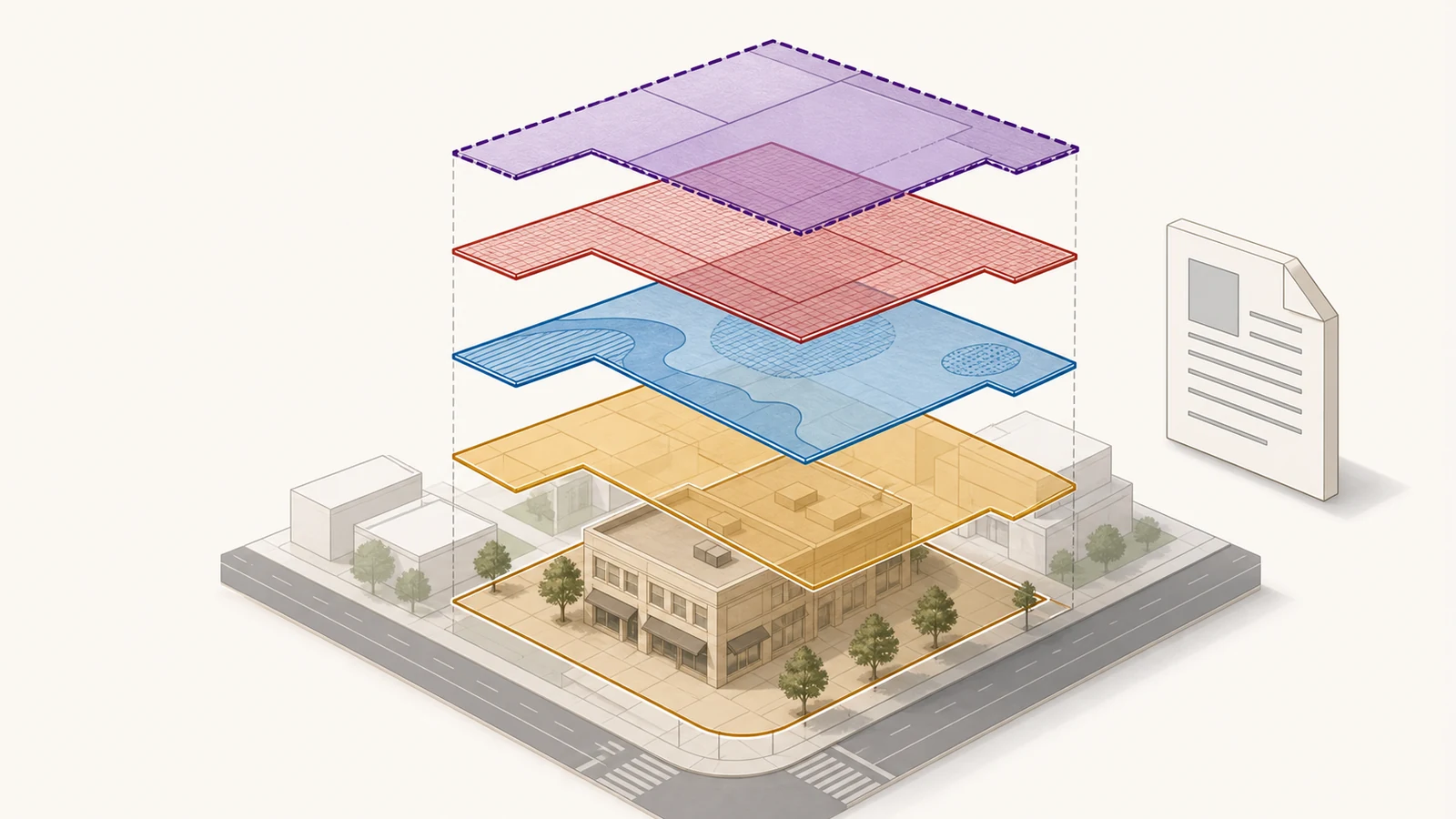
A base zoning label is not always the complete rule set for a property. An overlay, special district, plan district, combining district, or site-specific ordinance may add standards, replace part of the base-zone rules, or require a separate review. The safe method is to record every mapped layer for the parcel and trace each one to the current local code before deciding what the zoning allows.
This guide explains that research process for U.S. properties. Local governments use different names and different rule hierarchies, so a label that means one thing in Portland, Los Angeles, New York City, or Austin should never be decoded with a universal chart.
The base zone is only the first answer
The base zone usually establishes the starting rules for land use and development. Portland’s official base-zone guidance, for example, says its base zones identify allowed uses and development standards such as height, setbacks, and density. The same guidance tells users to check whether an overlay zone, plan district, or additional regulation also applies. That is the pattern to follow even when another city uses different terminology.
An overlay is generally a mapped layer for a particular subject or condition. A special or plan district is usually tied to a defined area and its planning goals. Both can affect the underlying zone, but the local ordinance—not the name of the layer—determines exactly how the rules interact.
| Record to capture | What it may control | Where to go next |
|---|---|---|
| Base zoning district | Starting use permissions, density, height, setbacks, lot coverage, or other development standards | The code chapter and use or development tables for that district |
| Overlay or combining district | A specific subject such as design, environmental resources, airport height, transit, historic resources, or additional use conditions | The overlay chapter, applicability section, map, and review procedure |
| Special or plan district | Rules written for a defined neighborhood, corridor, waterfront, downtown, or other planning area | The district chapter, subdistrict map, regulating plan, and referenced appendices |
| Site-specific case or ordinance | Conditions, approved plans, exceptions, planned development terms, or a parcel-specific zoning change | The adopted ordinance, final decision, exhibits, amendments, and effective date |
Do not stop when the map displays one familiar code. A result such as “R5” or “C2” may be accurate and still be incomplete if another layer appears in the property report, legend, zoning string, or case history.
Start with the parcel, not the map color
Before collecting layers, confirm that the map result belongs to the land you are researching. Address points can fall near a boundary, a corner property can contain more than one parcel, and a postal city name may not identify the government that controls zoning.
- Identify the city, county, township, borough, or other authority with land-use jurisdiction.
- Search the official planning or GIS system by address, then confirm the parcel number and boundary.
- If the address result is ambiguous, search by the local parcel identifier and compare the legal description.
- Check whether the project site includes multiple parcels or crosses a zoning boundary.
- Save the source URL, map or report date, parcel identifier, and a screenshot or PDF of the result.
If you have not yet found the correct authority or parcel, begin with the zoning lookup by address guide. The GIS zoning map guide explains how to distinguish an address point from the parcel and zoning polygons around it.
Build a complete list of every zoning layer
Use the official map as an inventory tool. Your first goal is not to interpret the proposal; it is to make sure no controlling layer has been missed.
1. Copy the full zoning designation
Record the complete string exactly as shown, including prefixes, suffixes, hyphens, parentheses, subdistrict names, and symbols. A shortened real-estate listing or assessor summary can remove the part that identifies an overlay or special condition.
2. Open the property details and layer list
Interactive maps often hide information in a property report, planning-and-zoning menu, “identify” panel, or layer control. Expand those panels and look for base zoning, overlays, special districts, plan districts, historic designations, regulating plans, zoning cases, and ordinances.
3. Turn layers on and inspect every boundary
A text result and a visible boundary answer different questions. Turn on the relevant layers, zoom to the parcel, and check whether the line crosses the parcel or project area. If the map scale is too coarse to settle the boundary, do not estimate from the screen.
4. Follow each designation to its own rule text
For every layer, locate the linked code chapter, ordinance, plan, or adopted map. Read the applicability provision first. Then check the use rules, development standards, review procedures, exceptions, definitions, and any subdistrict-specific table. The zoning map versus zoning code guide shows how to move from a label to the controlling text.
5. Record how the rules interact
Do not assume that the “most restrictive” number automatically wins, that every overlay replaces the base zone, or that a special district controls every subject. Find the local conflict, precedence, or modification provision. One layer may change height while leaving uses to the base zone; another may replace an entire table or require discretionary review.
What an overlay can change
Overlays are not one type of rule. They can address different planning concerns and may affect the project in very different ways. Portland’s official overlay guidance, for example, lists design, environmental, river, aircraft landing, noise, scenic resource, buffer, and other overlay zones. The presence of an overlay therefore tells you to open another rule set; it does not tell you the outcome by itself.
| Possible overlay subject | Questions to answer in the code |
|---|---|
| Design or neighborhood character | Is design review required? Is there an objective standards path, a discretionary review path, or an exemption? |
| Environmental, river, or resource protection | Which mapped resource is protected? Are disturbance limits, setbacks, reports, or environmental review required? |
| Historic resources | Does the zoning overlay regulate the property, or is a separate preservation commission and designation map involved? |
| Airport, noise, or view corridor | Are height, use, disclosure, sound attenuation, or agency-review rules triggered? |
| Transit, corridor, or mixed-use area | Are density, parking, frontage, use, affordability, or design standards modified? |
The category is only a signal to continue the research. The local map and adopted code must establish whether that particular overlay reaches the parcel and what it changes.
Special and plan districts are area-specific rulebooks
A special district or plan district usually carries rules designed for a defined area rather than a single subject applied citywide. Portland’s official zoning code says plan districts are tailored to a specific area, while overlay zones address particular subjects that may apply in different parts of the city. Both are used with a base zone and modify its regulations.
New York City uses its own legal framework. Section 11-123 of the NYC Zoning Resolution says a Special Purpose District is shown on the zoning maps over other districts and its regulations supplement or modify the underlying districts. That means a ZoLa result inside a special district must be followed to the applicable special-district article and any subdistrict map, not read from the base district alone.
Los Angeles uses terms such as Specific Plan, Historic Preservation Overlay Zone, Community Design Overlay, and supplemental districts. The correct response is the same: record the exact designation shown for the parcel, open its linked document, and determine which provisions apply to the proposed use or construction.
How four official systems expose the extra layers
| Jurisdiction and official source | What to capture | Important limit |
|---|---|---|
| Portland overlay-zone guidance | Base zone, every lower-case overlay symbol, plan district, and the linked Title 33 chapter | An overlay can change how the base rules work; the map symbol is not a substitute for its regulations. |
| Los Angeles ZIMAS guidance | Full zone string, HPOZ, Specific Plan, Community Design Overlay, other planning limitations, cases, and the applicable zoning code | ZIMAS supplies property information, but the linked planning documents and code provide the rules. |
| NYC zoning layers | Underlying zoning district, commercial overlay, special-purpose district and subdistrict, limited-height district, and map amendments | The city’s GIS data is an additional research source and does not replace the official zoning maps. |
| Austin Zoning by Address notice | Property Profile zoning, zoning text, ordinances, cases, overlays, regulating plans, and other mapped areas | The simple address dataset warns that it does not show all regulations, including overlays or cases where an address has more than one zoning. |
These examples are not a national definition. They show why the research method must be local: the map interface, terminology, legal hierarchy, and formal verification process all change by jurisdiction.
When two layers appear to conflict
A base-zone table and an overlay chapter may appear to give different answers. Before choosing one, work through the following checks:
- Applicability: Confirm that both provisions apply to the parcel, project type, and proposed use.
- Defined terms: Make sure the project is classified the same way in both chapters.
- Modification language: Look for words such as “supersedes,” “in addition to,” “except,” “modified by,” or “where in conflict.”
- Subdistrict rules: A district-wide standard may change again inside a named subarea.
- Adoption and effective dates: A recently adopted ordinance may not yet be effective, codified, or visible in every map layer.
- Site-specific decisions: A planned development, variance, conditional approval, or recorded condition may control part of the answer.
If the result depends on a property-specific decision, use the zoning change and variance records guide to find the final order, conditions, amendments, and effective date. A hearing notice or application status is not the final rule.
A worked example: one parcel, three rule layers
Suppose an official property report shows a mixed-use base zone, a design overlay, and a river plan district. The owner wants to add an upper floor and change the ground-floor use.
- Use the base-zone chapter to classify the proposed ground-floor use and find the starting height, floor-area, and setback standards.
- Open the design-overlay chapter to determine whether the alteration needs design review, meets an objective path, or qualifies for an exemption.
- Open the river plan-district chapter and map to confirm the subdistrict, then check river-specific height, setback, access, or review provisions.
- Read the interaction clauses. The plan district may change only selected base-zone standards while the design overlay controls a separate review.
- Search the parcel’s case history for earlier conditions or approved plans that still affect the site.
The answer is not “use the strictest layer.” The answer is a documented chain showing which layer governs each question. Keep the map result, code sections, plan-district map, case documents, and dates together so another reviewer can reproduce the research.
What the map result does not prove
A complete layer inventory is stronger than a single map label, but it is still research—not a permit, approval, survey, title report, or legal-use determination. It does not establish that an existing use was lawfully created, that a planned project satisfies every code, or that an overlay boundary has been surveyed on the ground.
For a purchase, financing, licensing, or development decision, ask the planning authority what form of written confirmation is available and what that document covers. Austin, for example, distinguishes its online Property Profile from an official Zoning Verification Letter. Even a verification letter may have a defined scope, so state the exact question you need answered.
If the map is unclear or appears out of date
Do not force a conclusion from a blurry boundary or an unexplained code. Prepare a short evidence package for the local planning office:
- Street address, parcel identifier, and legal description if available
- The full zoning string and every layer shown in the official system
- A dated screenshot or exported property report with the parcel selected
- The code sections, district chapters, or ordinances you reviewed
- A specific question, such as which height standard applies or whether a mapped line crosses the parcel
Also ask whether a recent map amendment has been adopted, whether it is effective, and whether the online map has been updated. If the exact location of a boundary controls the project, ask whether a survey, zoning confirmation, or other formal determination is required.
City guides for layer-specific research
For a Los Angeles parcel, use the Los Angeles ZIMAS guide to find the full zoning result, Specific Plans, HPOZ information, planning cases, and the code that applies. For New York City, the NYC ZoLa guide covers address and BBL lookup, commercial overlays, and special-purpose districts. The Chicago zoning map guide explains address and PIN searches and how to continue from a mapped designation to the city’s zoning records.
Questions property researchers often ask
Does an overlay replace the base zoning?
Not automatically. An overlay may add rules, modify selected standards, or supersede a base-zone provision only where the local code says it does. Read the overlay’s applicability and conflict provisions together with the base-zone chapter.
Can one property have more than one overlay?
Yes. Official systems can show several overlays or special areas for the same parcel. Record all of them and determine which ones apply to the proposed use, construction, or review.
How do I know whether a special district applies?
Confirm the parcel in the official zoning map or property report, turn on the special-district layer, and record the district and subdistrict. Then open the adopted district chapter and its map. Do not rely on a neighborhood name or nearby boundary alone.
Is a historic district always a zoning overlay?
No. Some jurisdictions incorporate historic-resource rules into zoning; others use a separate preservation designation, commission, map, and approval process. Check both the planning map and the responsible preservation agency before assuming that one system contains the whole answer.
Can I use a map screenshot as proof of legal use?
No. A screenshot documents what the map displayed on a particular date. Legal-use status may depend on permits, certificates of occupancy, licenses, prior approvals, nonconforming-use evidence, or a written agency determination.
Last checked July 28, 2026. Zoning maps, codes, district boundaries, and procedures can change. Reopen the linked government sources and confirm the effective rules for the parcel before relying on this research.