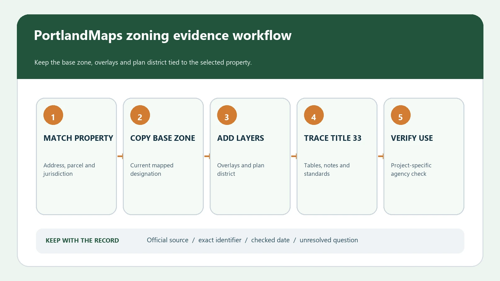
To look up Portland zoning by address, search the property in PortlandMaps, open Zoning & Districts, and record the base zone, every overlay zone, any plan district, the Comprehensive Plan designation, and the quarter-section map. Match the address to the correct tax lot before reading the code. Then trace each displayed layer to Portland Zoning Code Title 33. The online result is an official research route, but it is not a permit, land-use approval, survey, or parcel-specific legal determination.
The City of Portland’s zoning maps and regulations page explains the sequence: find the site on an official zoning map, identify the base zone and added layers, and then read the corresponding regulations. That sequence matters because a short label such as R5, RM2, CM2, or IG1 does not answer a project question by itself. A use table, development standard, overlay chapter, plan-district provision, or property-specific decision can change the practical answer.
Make sure Portland is the zoning authority
A Portland mailing address does not always mean the parcel is inside the City of Portland. Properties near city limits may be in another city or in unincorporated Multnomah, Washington, or Clackamas County. Start by confirming the jurisdiction shown for the selected tax lot. If Portland does not control land use there, stop and use the responsible city or county system instead of applying Portland’s Title 33 rules to the wrong property.
Next, confirm the property itself. Corner lots, tax lots with more than one address, condominium sites, campuses, recent land divisions, and an address placed near a boundary can produce a plausible but incorrect map selection. Compare the returned street address, tax-lot outline, tax account or property identifier, and visible building position. If a project includes more than one lot, save a separate result for each one.
| Identity check | What to save | Reason to pause |
|---|---|---|
| Jurisdiction | City and county shown for the property | The postal address is Portland but the parcel is outside city zoning authority |
| Search input | Complete address or intersection exactly as entered | Autocomplete selected a neighboring address or a different street direction |
| Tax lot | Property identifier and visible lot outline | The building or proposed work crosses more than one tax lot |
| Map reference | Quarter-section zoning map link or number | The online point and detailed map appear to disagree |
| Checked date | Date, official URL, and researcher notes | A saved screenshot has no source URL or date |
Find every zoning layer in PortlandMaps
The City’s PortlandMaps general-search guide directs users to the Zoning & Districts view for detailed zoning information. Do not stop at the short property summary. Open that view and record the base zoning, overlays, Comprehensive Plan entry, quarter-section zoning map, historic-resource information, and any listed plan district or land-use review reference that could affect the question. Save the exact capitalization and lowercase overlay letters; changing or dropping a character can point to a different chapter.
- Enter the full street address in PortlandMaps and choose the result whose location and tax-lot outline match the subject property.
- Open the property details and select Zoning & Districts rather than relying on the first summary line.
- Copy the base zone exactly, including its letters and numbers. Record overlay letters in a separate field.
- Record the Comprehensive Plan designation separately. Parentheses on a zoning map can represent the plan designation rather than today’s base zone.
- Check for a plan district, historic or conservation district, historic resource, recreational trail, or other displayed zoning feature relevant to the proposal.
- Open the detailed quarter-section map and compare the property’s location with visible district boundaries.
- Save the map route and date, then open the current Title 33 chapters for every layer you recorded.
If a layer seems absent, do not write “none applies” merely because it was not visible at one zoom level. Reopen the detailed zoning panel, inspect the quarter-section map, and check whether the project triggers a regulation that is not expressed as a colored overlay. The goal is a reproducible record of what the official tools showed, not a confident conclusion from a quick map glance.
Read the base zone without losing the added rules
Portland describes a base zone as the starting set of allowed uses and development standards. The City base-zone overview groups zones into single-dwelling residential, multi-dwelling residential, commercial or mixed use, employment and industrial, and campus institutional categories. It also explains that an allowed use can still be limited or require conditional-use review, while development standards can address matters such as height, setbacks, density, size, bulk, and location.
A base-zone answer is incomplete when another layer applies. Portland’s overlay-zone page says overlay rules sit on top of the base zone and can change how the base rules work. The plan-district page explains that a plan district can add requirements, allow exceptions, or modify base-zone, overlay, and other regulations; where its rules conflict, the plan-district provision can control. Read the chapters together rather than choosing the layer with the simplest answer.
| PortlandMaps field | What it tells you | What to read next |
|---|---|---|
| Base zone | The principal mapped zoning district | Title 33 zone chapter, use table, development standards, definitions, and table notes |
| Lowercase overlay letter | An additional subject-specific mapped rule | The chapter for every listed overlay and any cross-referenced review criteria |
| Plan district | A geography with added, modified, or exceptional rules | The named plan-district chapter and its relationship to the base and overlay rules |
| Comprehensive Plan designation | Long-range plan map designation | Do not substitute it for current zoning; investigate the amendment path only if relevant |
| Historic resource or district | A mapped historic-status clue | Current historic-resource and review rules for the proposed exterior or site work |
| Land-use review reference | A lead to a property-specific public case | Decision, approved plans, conditions, expiration, and later modifications |
Turn the map result into a project question
Zoning is easier to research when the proposed activity is concrete. “Can I use this property?” is too broad. State whether the proposal is a detached dwelling, additional dwelling unit, retail sales use, office, restaurant, warehouse, short-term rental, home occupation, new building, addition, sign, parking area, lot division, or change of occupancy. Record the expected floor area, height, setbacks, access, parking, outdoor activity, operating characteristics, and whether an existing structure or use will continue.
Classify the use using Portland’s current definitions before reading a use table. A business name or everyday label may cover more than one zoning use category. Then check the table symbol, all notes, use-specific standards, development standards, overlays, plan district, and any applicable land-use decision. If the classification is uncertain or a purchase or lease depends on it, ask Portland Permitting & Development for a written or project-specific route rather than selecting the most favorable category yourself.
| Question | Evidence needed | The map alone cannot prove |
|---|---|---|
| Is the proposed use allowed? | Exact use category, table status, notes, overlays, plan district, and prior decisions | That a nearby or existing use can be newly established |
| Can the building expand? | Lot dimensions, height, setbacks, floor area, site coverage, design and environmental rules | That the zone label authorizes the proposed plans |
| Can units be added? | Housing type, density or unit rules, lot configuration, services, overlays, and permit history | That assessor or listing data establishes lawful unit count |
| Does an old approval still help? | Decision, approved exhibits, conditions, effective date, expiration, and subsequent changes | That a case number transfers unchanged to a new proposal |
| Is a land-use review required? | Base rule, overlay and district triggers, proposal details, and current procedural code | That an allowed use avoids every review or building permit |
When the address or boundary does not line up
Stop and resolve mismatches before interpreting the code. Try the address without a unit, search the intersection, compare the tax lot in county property records, and open the quarter-section zoning map. For a recently divided or combined parcel, the tax system and zoning interface may update on different schedules. Keep the old and new identifiers in the research notes and ask the City which mapped record applies.
A line drawn on an online map is not a survey. If a district boundary, lot line, right-of-way, or environmental feature sits close to the work area, obtain authoritative clarification and the appropriate survey or technical evidence. Do not estimate a setback, zone split, or regulated area from screen pixels. Similarly, a missing online case does not prove no land-use decision exists; search alternate addresses and identifiers and use the City’s records route when the history matters.
Keep a Portland zoning evidence file
A useful evidence file allows another person to repeat the search. Preserve the address, jurisdiction, tax-lot identifier, base zone, each overlay, plan district, Comprehensive Plan designation, quarter-section map, related case numbers, code sections, checked date, and the exact proposal being tested. Quote only the rule needed for the issue and keep a link to the live official text. Mark open questions instead of turning uncertainty into a yes or no.
Use the zoning lookup by address guide when the street address is unreliable, and the parcel-number zoning workflow when a tax lot is the safer key. The overlays and special districts guide explains why added layers cannot be folded into the base code, while the zoning map versus zoning code guide helps separate mapped facts from regulatory interpretation.
Related official record checks
Use the guide that matches the exact agency, jurisdiction, tool, product, program, or record type; verify the live official source before acting.
Questions Portland property researchers ask
Does PortlandMaps show whether my project is approved?
No. It helps identify public property, zoning, district, and case information. Approval depends on the complete proposal, the current code, property-specific decisions, other development rules, and the City’s review.
What do lowercase letters after a Portland base zone mean?
They can identify overlay zones. Preserve each letter and open its current Title 33 chapter, because an overlay adds to or modifies the base-zone analysis. Do not assume every property has an overlay.
Is the zoning shown in parentheses the current zone?
The City explains that a parenthetical designation on its zoning map can be the Comprehensive Plan designation. Record it separately from the current base zone and do not report it as today’s zoning without an adopted map change.
Can I use an online parcel line for a setback measurement?
Not as a substitute for a survey or official determination. The online boundary helps select the property and organize research; precise development measurements require the evidence and review appropriate to the project.
Portland zoning maps, code provisions, property records, and agency procedures can change. Reopen the live official sources before relying on a result. Last reviewed August 6, 2026.