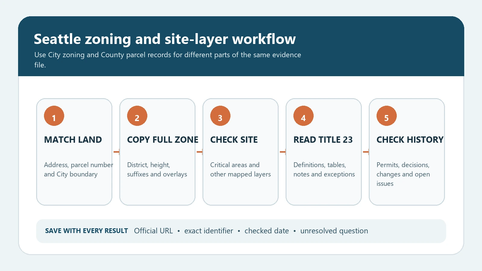
To check Seattle zoning by address, use the SDCI Property Information Map for City zoning and site layers, and use King County’s parcel tools to confirm the parcel number and property identity. Record the complete zoning designation, environmentally critical area layers, overlays or special designations, and the date checked. Then read the current Seattle Land Use Code for the exact use or development question. The map does not grant permission to build, operate a use, or ignore another review.
Seattle’s project and property research guide sends researchers to the SDCI Property Information Map for zoning and environmentally critical areas and to King County tools for parcel information. The City’s permit and site-history research quick sheet also identifies the Property Information Map as the place to select and display site data layers. This two-source method matters because the City interprets land-use rules while the county parcel record helps verify which land unit the address represents.
Start with parcel identity, not a colored zone
A street address can point to a condominium, a campus, a tax parcel containing several structures, or a building that crosses more than one lot. Search the address, select the parcel, and record the parcel number before interpreting the zoning label. King County notes that its parcel viewer can be searched by address or parcel number and can link to property and districts reports. Parcel boundaries shown online are research aids, not a substitute for a survey or legal description when a boundary controls the project.
| Identity check | Official route | Decision it prevents |
|---|---|---|
| Street address | SDCI and King County search | Using a nearby address with a different zone or site condition |
| Parcel number | King County Parcel Viewer | Confusing a mailing location with the land unit under review |
| City boundary | SDCI map and jurisdiction context | Applying Seattle code to unincorporated King County or another city |
| Selected feature | Click the parcel and inspect the highlighted geometry | Reading a map label from the opposite side of a street or zone line |
| Checked date | Research log | Presenting an old map result as current |
Seattle zoning lookup: a repeatable sequence
- Open Seattle’s research-a-project page and launch the SDCI Property Information Map from the official route.
- Enter the complete address or parcel number, select the correct parcel, and compare the footprint, streets, and neighboring lots.
- Turn on the zoning layer and copy the full designation. Preserve parentheses, suffixes, height numbers, pedestrian designations, MHA marks, and overlay labels exactly as displayed.
- Review environmentally critical area and other relevant site layers. A zoning district and a site constraint answer different questions and both may matter.
- Use the King County Parcel Viewer to confirm the parcel number and public parcel context. Do not treat approximate online lines as a boundary survey.
- Open the City’s official zoning and Land Use Code starting page and trace each element of the designation to the current section, table, definition, and map note.
- Check active permits, land-use decisions, recorded restrictions, prior approvals, and proposed code or map changes when they affect the decision.
- For a real project, ask SDCI or qualified local professionals about unresolved classification, boundary, nonconforming, critical-area, or permit questions.
Decode every part of the Seattle zoning label
Seattle designations can carry more information than a district family. A label may include a neighborhood residential, lowrise, midrise, commercial, Seattle Mixed, downtown, or industrial family; a height number; a pedestrian designation; Mandatory Housing Affordability notation; or another area-specific marker. Do not remove the part that appears secondary. The suffix or overlay may change height, floor-area, frontage, use, design, affordable-housing, or review requirements.
| Map element | Research meaning | Next source |
|---|---|---|
| District family | The principal zoning district shown for the parcel | Current Seattle Municipal Code Title 23 district provisions |
| Height number or range | A mapped height component that must be read with the district rules | Height and measurement provisions, exceptions, and map notes |
| P or pedestrian marker | A pedestrian-related designation may add street-level or use standards | Applicable pedestrian-zone and frontage provisions |
| M, M1, or M2 | A Mandatory Housing Affordability suffix may apply | Current MHA provisions and the exact zone designation |
| Overlay or special area | An additional area-specific rule layer | Overlay chapter, official map, and any site-specific decision |
| Environmentally critical area | A separate site-condition layer, not a zoning district | Critical Areas Code, mapped feature review, and site investigation |
The City explains on its zoning page that zoning districts are shown on the official land-use map and that the code determines how land is used and developed. That division of labor is why a map screenshot cannot answer a full project question. Use our zoning district meaning guide to separate the label from the legal standards, and the zoning code versus zoning map guide to build the source trail.
Check critical areas and other layers separately
Seattle’s site research can involve steep slopes, landslide-prone areas, wetlands, riparian corridors, liquefaction, flood-prone areas, shoreline rules, tree protections, landmark controls, or other mapped and unmapped conditions. A layer being absent from a quick map view does not guarantee that no regulated condition exists. Conversely, a generalized layer does not prove the exact field boundary. Record what the official tool shows, then identify whether the project requires a report, survey, geotechnical work, delineation, exception, or agency confirmation.
| Question | Minimum evidence | Unsafe shortcut |
|---|---|---|
| Can this use operate here? | Exact use definition, district use table, overlays and prior approvals | A nearby business or an old listing |
| Can the building reach this size? | Height, FAR, setbacks, lot coverage, amenity and measurement rules | The height number alone |
| Can housing units be added? | Unit, density, MHA, parking, design and building constraints | The parcel’s current unit count |
| Does an ECA affect the work? | Official layers, code triggers and site-specific technical evidence | A map color without field or agency review |
| Is a prior use or structure lawful? | Permit history, certificates, land-use decisions and nonconforming provisions | Assessor data or long occupancy alone |
Separate current zoning from permits and proposed changes
Current zoning, an active permit, an issued land-use decision, and a proposed rezone are different records. A permit application can be under review without changing the map. A council proposal or planning map can show a future direction without being effective law. A completed project may also carry conditions that do not appear in a general zoning label. Keep each record in its own row with an adoption, decision, issue, or effective date.
If the property is near a zone boundary or has a complicated approval history, start with the parcel-number zoning lookup guide. For multiple rule layers, use the overlays and special districts workflow. The Los Angeles ZIMAS guide provides a useful contrast: each city exposes different fields, so the Seattle result must be interpreted through Seattle’s tools and code.
Build a source-backed Seattle zoning worksheet
| Worksheet field | What to save | Verification rule |
|---|---|---|
| Subject property | Address, parcel number, city jurisdiction | All three must describe the same land unit |
| Zoning designation | Full label exactly as mapped | Do not drop suffixes, parentheses, heights, or pedestrian markers |
| Additional layers | ECA, overlay, shoreline, historic, design or other relevant flags | Keep zoning and site-condition layers separate |
| Code trail | Title 23 chapter, section, table, definition and note | Link to the current official text used for the conclusion |
| Permit and decision trail | Record number, type, status, decision date, conditions | An application is not an approval and an approval may carry conditions |
| Open issue | Boundary, use classification, nonconforming status, technical study | Escalate uncertainty instead of converting it to a yes/no |
| Checked | Date, researcher, official URLs | Recheck before money, construction, lease, or filing |
Seattle zoning map FAQ
Does King County zoning control inside Seattle?
Seattle zoning controls land inside the City of Seattle. King County parcel tools are valuable for parcel identity and county records, but unincorporated King County and other cities use different land-use authorities.
Does the SDCI map approve a project?
No. It is an official research tool. Approval depends on the current code, the complete project, site conditions, applicable permits, and agency review.
What if the zoning label contains M, M1, or M2?
Preserve the suffix and research the current Mandatory Housing Affordability provisions for that exact zone and proposal. Do not interpret only the base letters and height.
Can I rely on the parcel line shown online?
Use it for public-record research and parcel selection, but not as a legal survey. Obtain appropriate title, survey, or professional evidence when a boundary determines setbacks, area, ownership, or development rights.
Seattle zoning maps, code provisions, parcel records, and agency procedures can change. Verify the live official sources before relying on a result. Last reviewed August 6, 2026.