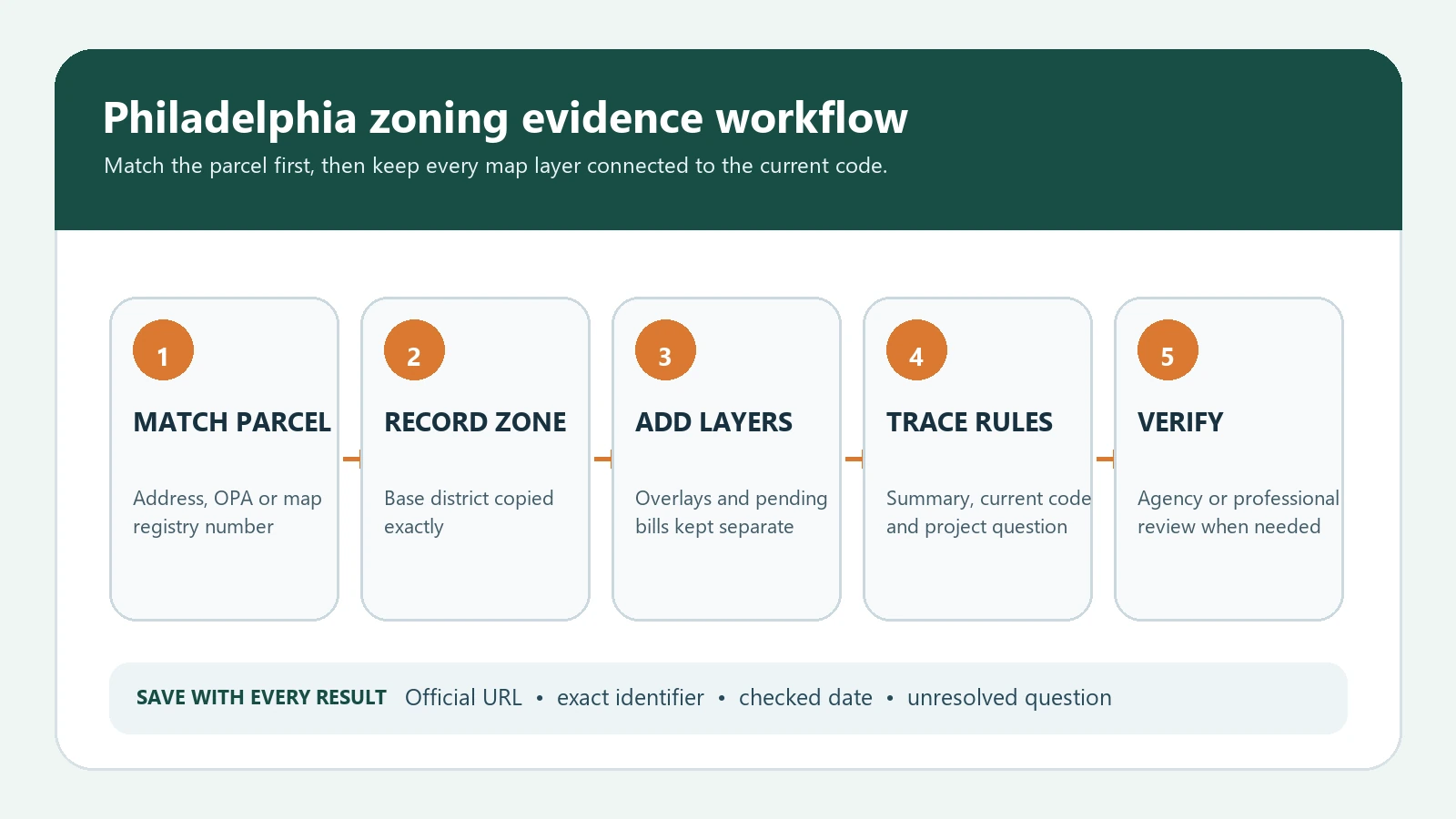
To look up Philadelphia zoning by address, start in the City’s Atlas, match the correct parcel, and open the Zoning section. Record the base district, every overlay, any pending zoning bill, and the parcel identifier. Then use the City’s Zoning Summary Generator and the current zoning code to investigate the rules that apply to the proposed use or work. A map label is a research starting point; it is not a permit, legal opinion, or approval.
The City describes Atlas as a front door to property information and says it can be searched by address, intersection, OPA account number, or Department of Records map registry number. Philadelphia’s location and zoning information page also directs users to Atlas for zoning boundaries and related property records. This guide turns those official tools into a repeatable evidence file instead of relying on a screenshot or a third-party real-estate label.
What to record before interpreting the zone
Address matching is the first control. Rowhouses, corner parcels, condominiums, merged lots, and recent address changes can produce more than one plausible result. Do not copy a zoning code until the street number, parcel shape, OPA account or map registry number, and visible building location describe the property you mean. If a proposal spans two parcels, research each parcel separately before combining the findings.
| Evidence field | Where to find it | Why it matters |
|---|---|---|
| Search input | Atlas search box | Preserves the exact address, intersection, OPA account, or map registry number used |
| Parcel identity | Selected parcel and account details | Prevents a nearby or similarly named address from becoming the research subject |
| Base district | Atlas Zoning section | Identifies the first Title 14 district to investigate |
| Overlay district | Atlas Zoning section | May add or change use, design, signage, parking, dimensional, or review rules |
| Pending bill | Atlas Zoning section when shown | Flags a proposed map change that should not be treated as adopted zoning |
| RCO information | Atlas zoning and nearby records | Helps identify community-review contacts; it does not decide what is permitted |
| Checked date | Your evidence log | Shows when a changeable public record was reviewed |
Philadelphia Atlas zoning lookup: step by step
- Open Philadelphia Atlas and enter the complete street address. If the address is ambiguous, try the OPA account or map registry number.
- Zoom to the parcel and compare the parcel outline with the building, corner, alley, and adjacent lots. Select the parcel itself rather than relying on the first autocomplete result.
- Open the Zoning section and write down the base district exactly, including every letter, number, slash, dash, and suffix.
- Record each overlay separately. If Atlas shows a pending bill, capture the bill identifier and current status instead of merging it into the adopted base zoning.
- Save the parcel identifier, official result URL if available, and date checked. A screenshot is useful only when the text record and source URL are saved with it.
- Open the Philadelphia Zoning Summary Generator for a structured summary, then trace the relevant question to the current code and official City guidance.
- For a purchase, lease, business opening, addition, conversion, sign, or development decision, verify the intended use and scope with the Department of Licenses and Inspections or qualified Philadelphia land-use counsel.
How to read base districts, overlays, and pending bills
The base district is not automatically the entire answer. Philadelphia uses residential, commercial, industrial, special-purpose, and other district families, while overlays can target a corridor, neighborhood, environmental condition, design issue, or particular standard. An overlay may leave most base rules in place and modify only selected questions. A pending bill is different again: it signals proposed legislation and should not be reported as the current adopted map unless the legislative and effective status confirms that result.
| Atlas result | What it can support | Required next check |
|---|---|---|
| Base district code | The mapped district shown for the selected parcel | Open the current Title 14 district rules and applicable use and dimensional tables |
| One or more overlays | Additional mapped rule layers | Read the section for every overlay; do not assume the base district controls a conflicting question |
| Pending zoning bill | A proposal may affect the parcel | Check bill text, amendments, passage, mayoral action, and effective date |
| No overlay displayed | Atlas did not show one in that view | Check other applicable plans, historic, flood, airport, subdivision, or site-specific controls as the project requires |
| Boundary close to parcel | The property may be near a district edge | Confirm the selected parcel and request authoritative clarification when the line placement matters |
Use the City’s Philadelphia Zoning Code Quick Guide to learn the structure and common base-district concepts, but follow the City’s own warning that a quick guide is not a substitute for adopted ordinances or codes. The distinction is important when a table note, exception, overlay, use-specific standard, or later amendment changes the general summary. Our zoning code versus zoning map guide explains why the map answers where while the code answers what the mapped label means.
Turn a zoning lookup into a project-specific check
A useful zoning file states the proposed activity in concrete terms. “Retail,” “restaurant,” “home business,” “addition,” or “apartment” may still be too broad. Record whether the proposal changes the principal use, adds an accessory use, increases floor area or height, changes occupancy, alters parking or loading, installs a sign, creates units, affects a corner side, or involves outdoor activity. Then match each feature to a code question rather than asking whether the zoning is simply good or bad.
| Project question | Evidence to collect | Do not conclude from Atlas alone |
|---|---|---|
| Is the use allowed? | Exact use classification, base district, overlays, use table and use-specific standards | That a similar business exists nearby |
| Can the building expand? | Lot dimensions, occupied area, height, yards, setbacks, open area, existing conditions | That the parcel has a commercial or residential label |
| Can units be added? | Density rules, dwelling-unit calculation, overlays, existing lawful unit record | That the assessor or listing shows a certain bedroom or unit count |
| Is a sign allowed? | Sign type, area, height, illumination, frontage, overlay and permit rules | That another storefront displays a similar sign |
| Is a variance needed? | Applicable prohibition or dimensional conflict and the current permit decision | That the project appears unusual or difficult |
Common Philadelphia lookup mistakes
- Searching the mailing address but selecting the wrong parcel in a multi-parcel site.
- Dropping suffixes or overlay codes when copying the zoning designation.
- Treating a pending bill as if it already changed the official zoning map.
- Using the Zoning Summary Generator as a permit determination instead of a research aid.
- Assuming an existing use proves that the same use can be newly established today.
- Ignoring lawful nonconforming use, prior approvals, provisos, certificates, appeals, or property-specific permits.
- Reporting zoning as approval while leaving building, fire, accessibility, health, historic, subdivision, or other reviews unchecked.
A citation-ready Philadelphia zoning evidence log
For due diligence or a published explanation, keep a short, reproducible log. This makes the work easier to audit and gives another researcher enough information to repeat the lookup without exposing private client notes.
| Log column | Example format | Quality control |
|---|---|---|
| Property searched | Street address plus OPA or map registry number | Use only public identifiers needed to distinguish the parcel |
| Official tool | Philadelphia Atlas | Link directly to the City tool or stable City information page |
| Mapped findings | Base district; overlays; pending bill | Copy exact codes and keep categories separate |
| Code path | Title 14 chapter, section, table, note | Record the provision actually used, not only a search-result snippet |
| Open question | Use classification; overlay applicability; prior approval | State uncertainty instead of filling it with an assumption |
| Checked | 2026-08-06 with researcher initials | Recheck before a decision because maps and rules change |
For the broader workflow, use the zoning lookup by address guide. When Atlas reports more than one rule layer, continue with the zoning overlays and special districts guide. The Chicago zoning map guide is a useful comparison showing why each city’s official tool, parcel keys, and code path must be handled separately.
Related official record checks
Use the guide that matches the exact agency, jurisdiction, tool, product, program, or record type; verify the live official source before acting.
Philadelphia zoning map FAQ
Does Atlas prove a proposed use is permitted?
No. Atlas identifies public property and zoning information for research. A use decision can depend on exact classifications, overlays, existing approvals, provisos, nonconforming rights, code changes, and the details of the proposal.
What if Atlas shows more than one parcel?
Match the building and parcel identifiers carefully. Research each parcel affected by the proposal and ask the City for clarification if a boundary or parcel configuration changes the result.
Is the Zoning Summary Generator the final code?
No. It is a practical official summary tool. The current adopted code, applicable ordinances, map, approvals, and agency interpretation control when a general summary conflicts or leaves a question open.
Does a pending bill change the zoning today?
Not necessarily. Record it as pending and check the legislative record, passage, effective date, and any later amendment before describing the parcel’s current zoning.
Philadelphia maps, code provisions, bills, and agency procedures can change. Verify the live City record before relying on a result. Last reviewed August 6, 2026.