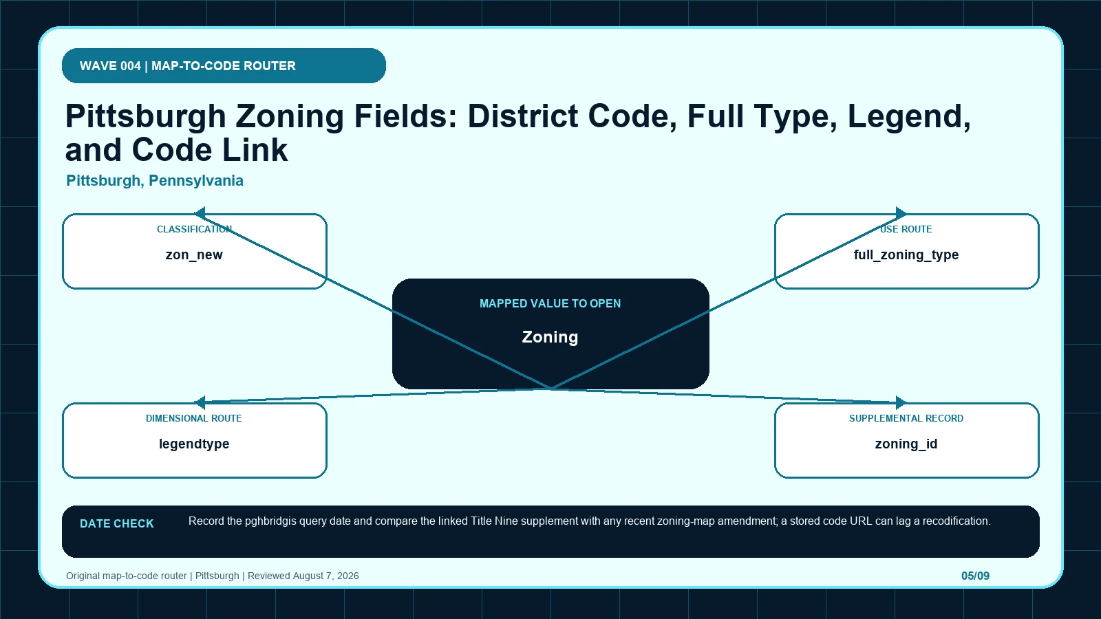
The pghbridgis record supports a three-way Pittsburgh check among the district abbreviation, expanded zoning type, and direct municipal-code link. Status and service currency still have to be compared with the current Title Nine supplement and any later map amendment. It is not an approval.
Last checked: August 7, 2026.
Begin the abbreviation-to-Title-Nine check at Pittsburgh Zoning Map, which supplies official parcel and zoning lookup. Cross-check the selected geometry through Pittsburgh base Zoning layer, the route used for current district field schema. Before copying Zoning (layer 0), verify pghbridgis.pittsburghpa.gov city host and federated Zoning MapServer layer 0; those markers keep the pghbridgis code route tied to the intended jurisdiction and record period.
zon_new and full_zoning_type should agree before Title Nine is opened
Pittsburgh's base layer supports several internal cross-checks before the code is opened. zon_new carries the public abbreviation, such as P or LNC. full_zoning_type expands that abbreviation, and legendtype places it in a readable legend family. zoning_id is an internal dataset identifier; a value such as 3 must not replace LNC in public prose. The municode field points toward the district provision, although the current sampled destination resolves to eCode360 and still requires fresh cross-reference review. status can read Approved, but that describes the mapped zoning record rather than a building permit or proposed project. Layer 0 is the base geography, so a riverfront or other overlay belongs in an additional check. The strongest answer reconciles zon_new, full_zoning_type, and the live code destination while keeping legend, identifier, status, and overlays in their narrower roles.
| Returned local record | Record to compare | When to stop | Next decision |
|---|---|---|---|
| Zoning (layer 0) returns official layer ID 0 | Compare with zon_new, which stores the current district abbreviation | Stop the abbreviation-to-Title-Nine check if zon_new is missing, dated differently, or points to another record. | Continue through the pghbridgis code route: Confirm parcel geometry before reading district rules. Then test whether zon_new changes that route. |
| zon_new returns P; LNC | Compare with full_zoning_type, which expands the district name | Stop the abbreviation-to-Title-Nine check if full_zoning_type is missing, dated differently, or points to another record. | Continue through the pghbridgis code route: Search the exact abbreviation in Title Nine. Then test whether full_zoning_type changes that route. |
| full_zoning_type returns PARKS AND OPEN SPACE; LOCAL NEIGHBORHOOD COMMERCIAL | Compare with legendtype, which stores the legend grouping | Stop the abbreviation-to-Title-Nine check if legendtype is missing, dated differently, or points to another record. | Continue through the pghbridgis code route: Use it to verify the code-to-name pairing. Then test whether legendtype changes that route. |
| legendtype returns Parks; Local Neighborhood Commercial | Compare with zoning_id, which stores the dataset district identifier | Stop the abbreviation-to-Title-Nine check if zoning_id is missing, dated differently, or points to another record. | Continue through the pghbridgis code route: A legend group is explanatory, not an independent permission. Then test whether zoning_id changes that route. |
| zoning_id returns 2; 3; 4 | Compare with municode, which links toward a district code provision | Stop the abbreviation-to-Title-Nine check if municode is missing, dated differently, or points to another record. | Continue through the pghbridgis code route: Use it for data reconciliation, not as the public zoning code. Then test whether municode changes that route. |
| municode returns current sampled links resolve to eCode360 district sections | Compare with status, which states the mapped record status | Stop the abbreviation-to-Title-Nine check if status is missing, dated differently, or points to another record. | Continue through the pghbridgis code route: Reopen the current code and follow cross-references and exceptions. Then test whether status changes that route. |
| status returns Approved | Compare with Zoning (layer 0), which returns the base zoning district | Stop the abbreviation-to-Title-Nine check if Zoning (layer 0) is missing, dated differently, or points to another record. | Continue through the pghbridgis code route: Confirm that Approved describes the zoning row and does not replace a permit or project approval. Then test whether Zoning (layer 0) changes that route. |
legendtype, zoning_id, municode, and status each carry a different job
The pghbridgis code route table keeps each returned label beside its displayed scope and the separate legal record still waiting to be opened. Its first checkpoint is Zoning (layer 0), which may appear as official layer ID 0; from there, Confirm parcel geometry before reading district rules. A blank in the abbreviation-to-Title-Nine check stays visible so another reader can distinguish an empty official return from an unexamined field.
| Local field, layer, or record | What it does | Displayed value or scope | Next code or record check | Official page |
|---|---|---|---|---|
| Zoning (layer 0) layer | returns the base zoning district | official layer ID 0 | Confirm parcel geometry before reading district rules. | Open exact record |
| zon_new field | stores the current district abbreviation | P; LNC | Search the exact abbreviation in Title Nine. | Open exact record |
| full_zoning_type field | expands the district name | PARKS AND OPEN SPACE; LOCAL NEIGHBORHOOD COMMERCIAL | Use it to verify the code-to-name pairing. | Open exact record |
| legendtype field | stores the legend grouping | Parks; Local Neighborhood Commercial | A legend group is explanatory, not an independent permission. | Open exact record |
| zoning_id field | stores the dataset district identifier | 2; 3; 4 | Use it for data reconciliation, not as the public zoning code. | Open exact record |
| municode field | links toward a district code provision | current sampled links resolve to eCode360 district sections | Reopen the current code and follow cross-references and exceptions. | Open exact record |
| status field | states the mapped record status | Approved | Confirm that Approved describes the zoning row and does not replace a permit or project approval. | Open exact record |
Use the pghbridgis layer to reach the live Pittsburgh code
- Open the pghbridgis code route; fix the parcel, boundary, jurisdiction, and official key before reading thematic records.
- Start the abbreviation-to-Title-Nine check by copying Zoning (layer 0) exactly as returned, including official layer ID 0.
- Keep zon_new in a second pghbridgis code route worksheet field because it stores the current district abbreviation.
- Test full_zoning_type independently, then mark its value, service layer, or documented blank in the abbreviation-to-Title-Nine check.
- Give legendtype and every later item a separate row; never compress history, plans, and overlays into the pghbridgis code route result.
- Attach the pghbridgis code route lookup time to Zoning (layer 0), while preserving this separate currency clue: Record the pghbridgis query date and compare the linked Title Nine supplement with any recent zoning-map amendment; a stored code URL can lag a recodification.
- If Zoning (layer 0) and zon_new conflict, send the abbreviation-to-Title-Nine check to Pittsburgh Zoning Map and ask whether the stored code link still points to the current provision.
The pghbridgis code route worksheet is complete only when another reader can reproduce the abbreviation-to-Title-Nine check from the same parcel key and official pages. Keep each source's legal role and effective date apart, then record whether the stored code link still points to the current provision as unresolved instead of selecting the most convenient output. The local currency note remains part of that audit trail: Record the pghbridgis query date and compare the linked Title Nine supplement with any recent zoning-map amendment; a stored code URL can lag a recodification.
A district value paired with a stored municode route
Imagine a hypothetical Pittsburgh parcel selection where layer 0 returns zon_new LNC, full_zoning_type LOCAL NEIGHBORHOOD COMMERCIAL, legendtype Local Neighborhood Commercial, zoning_id 3, status Approved, and a municode link. The reviewer can use the expanded name to confirm the LNC pairing and follow the link to the current Title Nine material. The public note should never say the parcel is 'zoned 3,' nor should Approved be rewritten as approval for a store, renovation, or permit. A separate overlay intersection remains a separate question. This is a hypothetical schema exercise rather than a claim about an existing address or use. It illustrates a reproducible audit trail: capture parcel geometry, retain LNC, verify its expanded type, note the internal ID only for reconciliation, and read current exceptions and cross-references before discussing standards.
Recodification can leave a correct polygon beside an obsolete URL
| Local situation | What went wrong | What to retain | How to resolve it |
|---|---|---|---|
| Scenario 1 | zoning_id 3 is reported as a zoning designation instead of the public code LNC. | Preserve full_zoning_type, the selected geometry, and both timestamps from the pghbridgis code route check. | Use Pittsburgh Zoning Map to settle whether the stored code link still points to the current provision; then Use it to verify the code-to-name pairing. |
| Scenario 2 | A riverfront or other overlay is substituted for base layer 0 rather than added to it. | Preserve legendtype, the selected geometry, and both timestamps from the pghbridgis code route check. | Use Pittsburgh Zoning Map to settle whether the stored code link still points to the current provision; then A legend group is explanatory, not an independent permission. |
If a Pittsburgh result substitutes zoning_id for zon_new or lets an overlay stand in for layer 0, rebuild the record from the parcel geometry. Copy the exact abbreviation, compare it with full_zoning_type and legendtype, and keep zoning_id as an internal reconciliation value. Reopen the municode destination and record where it resolves now. Treat status as the status of the zoning row only. When the map, expanded name, and current code do not align, provide City Planning with the parcel reference and query capture. Ask: 'Is LNC the current base designation for this polygon, what legal provision now corresponds to the service's stored code link, and must a riverfront or other overlay be reviewed separately?' This exact question separates base-zone identity, code currency, and supplemental geography instead of requesting a general statement that a project is allowed.
Map query, Title Nine supplement, and amendment have separate dates
Pittsburgh, Pennsylvania date check: Record the pghbridgis query date and compare the linked Title Nine supplement with any recent zoning-map amendment; a stored code URL can lag a recodification.
The Pittsburgh service and the code link can age on different schedules. A stored URL may redirect after recodification, while the base polygon may reflect a map amendment that needs its own effective date. status Approved does not solve that timing question and cannot be borrowed as a project entitlement. Save the Pittsburgh pghbridgis query date, reopen the destination behind municode, and compare the current Title Nine supplement with recent zoning-map actions. Base layer 0 and its published fields do not include Riverfront or other overlay rules; those controls must be added through their own source. This distinction prevents a newer code page from being treated as proof that the mapped geometry is current, or a current polygon from being treated as proof that every stored code link still lands on the controlling provision.
The Zoning Map and City Planning page close different gaps
| Official page | What to check there | Local coverage shown |
|---|---|---|
| Pittsburgh Zoning Map | official parcel and zoning lookup | City GIS application |
| Pittsburgh base Zoning layer | current district field schema | City-owned pghbridgis service |
| Pittsburgh zoning | code and planning guidance | Official City Planning page |
How should Zoning (layer 0) be checked in Pittsburgh, Pennsylvania?
Open the official Zoning (layer 0) record and capture the value inside the pghbridgis code route. That record shows how Zoning (layer 0) returns the base zoning district; one displayed form is official layer ID 0. Place the copied value in the abbreviation-to-Title-Nine check, then follow its separate rule route: Confirm parcel geometry before reading district rules.
How should zon_new be checked in Pittsburgh, Pennsylvania?
Open the official zon_new record and capture the value inside the pghbridgis code route. That record shows how zon_new stores the current district abbreviation; one displayed form is P; LNC. Place the copied value in the abbreviation-to-Title-Nine check, then follow its separate rule route: Search the exact abbreviation in Title Nine.
How should full_zoning_type be checked in Pittsburgh, Pennsylvania?
Open the official full_zoning_type record and capture the value inside the pghbridgis code route. That record shows how full_zoning_type expands the district name; one displayed form is PARKS AND OPEN SPACE; LOCAL NEIGHBORHOOD COMMERCIAL. Place the copied value in the abbreviation-to-Title-Nine check, then follow its separate rule route: Use it to verify the code-to-name pairing.
- Selected parcel key, geometry, and responsible jurisdiction
- Every returned value from the local field table
- Page titles, URLs, lookup times, and update clues
- Opened code, plan, case, ordinance, or metadata records
- Unresolved blanks, boundary splits, dates, and competing outputs
- Proposed activity stated in code-relevant facts
- Agency contact, narrow question, reply date, and limits
The pghbridgis code route does not decide title, survey boundaries, private restrictions, vested rights, building-code compliance, utilities, licensing, or permit issuance. Request a written response when the abbreviation-to-Title-Nine check leaves competing official results or when substantial reliance is planned. A useful request to Pittsburgh Zoning Map identifies the parcel, quotes Zoning (layer 0) and zon_new, gives their source dates, and asks whether the stored code link still points to the current provision.
Use pittsburgh zoning map by address, zoning code vs zoning map, zoning overlays special districts only where those methods clarify the abbreviation-to-Title-Nine check. The pghbridgis code route evidence linked for Zoning (layer 0) and zon_new remains the local starting point.
Reviewed August 7, 2026. Recheck the pghbridgis code route, its cited ordinance, and the agency procedure before relying on the saved worksheet.