Quick answer: Use NYC Planning's ZoLa for the current zoning-map research step: search the address, confirm borough-block-lot, select the correct parcel, and record every mapped district, special-purpose district, overlay, and landmark or waterfront indicator shown for that lot.
Make ZoLa the owner for the NYC address-and-map task
- Resolve the parcel identity before copying a zoning district.
- Open the Zoning Resolution text for the district and the proposed use or development question.
- Check amendments and active applications when timing matters, and retain the map date or saved record.
What this result does not prove
ZoLa does not by itself prove legal use, vested rights, buildable area, permit eligibility, or the outcome of an agency interpretation.
Verify the live rule at NYC Planning ZoLa. Then continue with the map-versus-code guide for the next step.
Use the official NYC ZoLa map to search a New York City address or borough-block-lot number. Confirm that the highlighted tax lot is the property you mean, record the base zoning district and every intersecting layer, and then open the current Zoning Resolution. A ZoLa screen is a research starting point; it is not a permit, legal-use determination, or approval of a proposed project.
This process is useful before a purchase, lease, renovation, conversion, or development discussion. Keep the address, BBL, proposed use, map layers, and date checked together so another person can reproduce the same search.
Start with the official NYC source
ZoLa is the New York City Department of City Planning’s public zoning and land-use map. The official interface, its user guide, and the current zoning text answer different parts of the check; no single screen settles the whole property question.
| Source | Use it to check | Do not treat it as |
|---|---|---|
| NYC ZoLa | The selected lot, BBL, base district, overlays, special districts, and related map layers. | A permit, certificate of occupancy, or project approval. |
| ZoLa User Guide | How address and BBL searches, result panels, layers, map links, and metadata work. | Evidence that a particular use is legal at one property. |
| NYC Zoning Resolution | The current definitions and rules attached to a mapped district or special district. | A parcel-specific agency interpretation. |
If a saved link or search result uses a different host, return to the official ZoLa page before relying on it. A third-party parcel site can be useful for orientation, but it should not replace the city map and current rule text.
Match the address to the right tax lot
An address can point to the wrong entrance, an adjoining parcel, or only one part of a multi-lot site. ZoLa also supports a BBL search, which is usually the safer route once you know the borough, block, and lot.
- Search the street address and select the correct borough.
- Check the highlighted lot outline instead of relying only on the pin or address label.
- Copy the BBL shown in the result panel and compare it with the property record you are using.
- If the address is ambiguous, search again by borough, block, and lot.
- For a corner, campus, condominium, assemblage, or split site, repeat the check for every relevant lot.
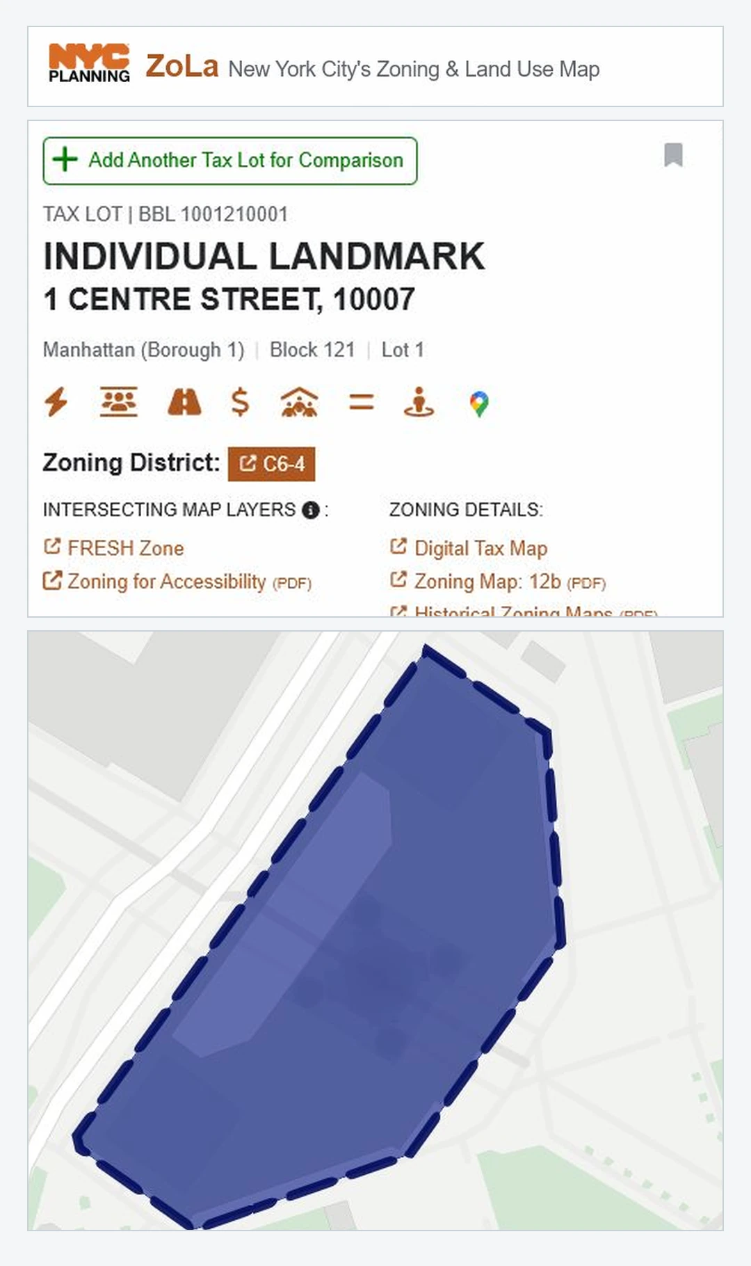
Do not continue to rule interpretation until the address, BBL, and highlighted boundary agree. A correct zoning label attached to the wrong lot is still the wrong answer.
Turn one ZoLa result into a record another person can verify
A useful ZoLa record keeps the search input, selected tax lot, mapped zoning, added controls, case links, and source date together. BBL identifies a tax lot, not necessarily a zoning lot or the full project site. The table below separates what each result can support from what still needs an official rule, project file, or agency response.
| ZoLa evidence | What to record, what it means, and where to go next |
|---|---|
| Accepted search input Address, borough/block/lot, intersection, or place of interest | Record: The exact input, borough, selected outline, result URL, and checked time. Use: Address and BBL searches can lead to a lot-level result. An intersection only locates a point until a lot is selected. Does not prove: That the first marked location is the intended tax lot. Next: Match the highlighted outline and BBL before reading zoning. Official ZoLa User Guide |
| Tax-lot identity Borough, block, lot, and 10-digit BBL | Record: Borough, block, lot, zero-padded BBL, address, lot outline, and every BBL in a multi-lot site. Use: A BBL is one borough digit, five block digits, and four lot digits. Does not prove: A zoning lot, project boundary, title, surveyed boundary, or one-building identity. Next: Resolve address-BBL conflicts before continuing. Official PLUTO data dictionary |
| Base zoning ZoneDist1-4, ZONEDIST, and ZoneMap | Record: Every populated district field, the zoning map sheet, visible geometry, source version, and checked time. Use: These values identify the mapped district labels and the map sheet to investigate. Does not prove: A permitted use, legal occupancy, buildable floor area, permit, or approval. Next: Open the current district rules and definitions in the NYC Zoning Resolution. |
| Split boundary SplitZone and repeated district fields | Record: SplitZone, ZoneDist2-4, Overlay2, SPDist2-3, full map scale, and the apparent boundary. Use: In MapPLUTO, SplitZone is Y when a second district, overlay, or special-district value is populated. Does not prove: The exact boundary line, area percentage, or how split-lot rules apply to the proposed work. Next: Inspect the live geometry and seek a property-specific interpretation when the line matters. Official MapPLUTO metadata |
| Commercial overlay Overlay1-2 and OVERLAY | Record: Every overlay value, the underlying district, visible boundary, source date, and checked time. Use: The official layer maps commercial-overlay designations within tax blocks. Does not prove: That the overlay replaces the base district, covers the whole lot, or permits a proposed business. Next: Read the overlay and base-district rules together. Official commercial-overlay layer |
| Special-purpose controls SPDist1-3, main district, subdistrict, and sub-area fields | Record: Main district name and label, every subdistrict or sub-area, intersecting boundaries, and checked time. Use: NYC Planning publishes main special-purpose districts separately from their internal subdistricts and sub-areas. Does not prove: That the base district alone controls or that a blank summary field excludes every special rule. Next: Open the applicable special-purpose chapter and maps. Main districts and subdistricts |
| Limited-height control LtdHeight, LHNAME, and LHLBL | Record: The limited-height name and label, intersecting geometry, and checked time. Use: It is a pointer to an added zoning control. Does not prove: A complete building-height calculation, landmark approval, building-code compliance, or permit. Next: Open the controlling text and check every other applicable height rule. Official limited-height layer |
| Zoning map or amendment ZoneMap, ZMCode, PROJECT_NAME, STATUS, ULURPNO, LUCATS, and EFFECTIVE | Record: Map sheet, project name, status, ULURP number, LUCATS code, effective date, geometry, and checked time. Use: The amendment layer can route a mapped area to an adopted, proposed, or certified public record. Does not prove: That one polygon equals one project, that a proposal was adopted, or that an action governs the exact lot today. Next: Search the identifier in NYC Planning ZAP and read the underlying public documents. Official amendment layer |
| Source date and final follow-through ZoLa checked time, layer metadata, MapPLUTO version, rule and case links | Record: The live ZoLa URL, retrieval time, metadata date, release version, exact Zoning Resolution sections, ZAP project URL, and agency response. Use: It lets another person reopen the same evidence chain. Does not prove: That a service edit date is a legal effective date or that all ZoLa layers share one update cycle. Next: Refresh after a known action and before a purchase, lease, filing, or construction decision. Official ZoLa FAQ |
Download: NYC ZoLa field and evidence crosswalk (CSV). The normalized file includes accepted inputs, BBL and tax-lot fields, zoning and overlay fields, special-district and amendment identifiers, source dates, interpretation limits, and refresh triggers.
What the public NYC Planning layers contained when checked
This is a fixed API snapshot, not a live counter. Its rows use several different units: a MapPLUTO tax-lot polygon feature record, a zoning polygon, an overlay polygon, a special-district polygon, or an amendment polygon. Those units must not be combined or cited as counts of properties, projects, approvals, legal uses, or development rights.
| Public-data result | Correct reading and limit |
|---|---|
| MapPLUTO version 26v1 | Correct reading: Distinct Version value returned by the current public MapPLUTO service. Limit: It is not the version for every ZoLa layer or a legal effective date. Official source |
| MapPLUTO features 856,614 tax-lot polygon records | Correct reading: Polygon feature records returned by the shoreline-clipped MapPLUTO FeatureServer. Limit: Not unique properties, buildings, owners, zoning lots, or the separate non-geographic PLUTO Only table. Official count query |
| Zoning districts 5,416 polygon records | Correct reading: Public zoning-district feature records in the current layer. Limit: Not tax lots, properties, legal determinations, or approvals. Official layer estimate |
| Commercial overlays 9,623 polygon records | Correct reading: Public commercial-overlay feature records. Limit: Not affected-lot count, permitted-business count, or approval count. Official layer estimate |
| Special-purpose boundaries 95 main-district and 336 subdistrict or sub-area polygon records | Correct reading: Separate feature counts for the main-boundary and internal-subdistrict services. Limit: Not affected lots, one universal rule list, projects, or approvals. Main-district estimate and subdistrict estimate |
| Limited-height districts 14 polygon records | Correct reading: Public limited-height feature records. Limit: Not affected lots or a complete height calculation for any property. Official layer estimate |
| Zoning map amendments 1,414 polygon records | Correct reading: Public amendment features in the service scope, which includes adopted and proposed changes since 2002 and current certified rezonings. Limit: Not unique cases, adopted actions only, approvals, or affected tax lots. Official layer estimate |
| Published zoning release date May 20, 2026 | Correct reading: Date of the most recent City Council adoptions included in the May 2026 GIS zoning release listed when checked. Limit: A later technical service edit date is not automatically a later legal adoption date. Official BYTES release page |
Download: NYC ZoLa and zoning-layer public-data snapshot (CSV). It preserves every query URL, source scope, row unit, release or edit date, derivation, and interpretation limit.
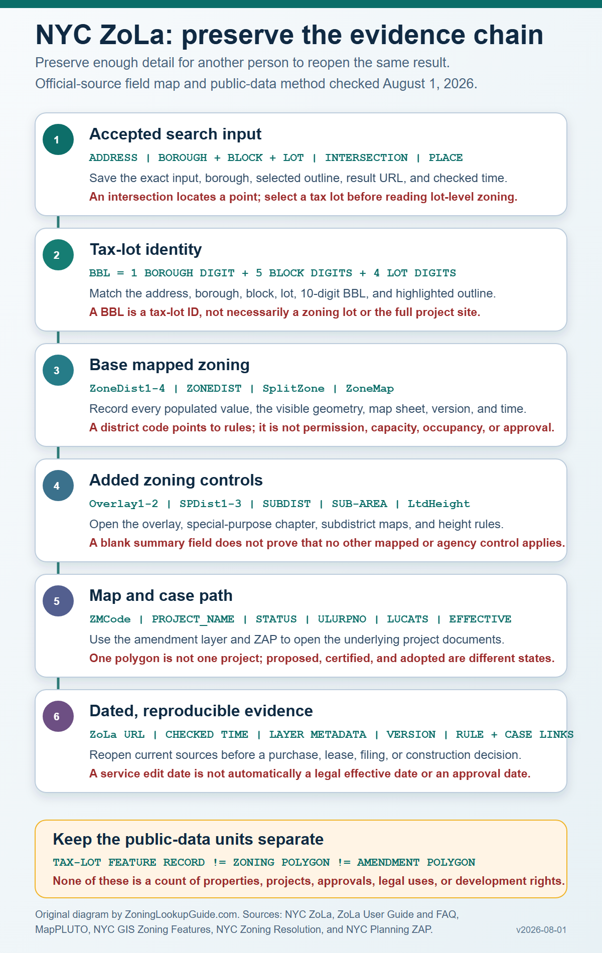
Method: Search behavior was normalized from the official ZoLa User Guide and FAQ. Field names and feature units were verified against MapPLUTO and the six NYC GIS zoning feature classes. Counts came from public ArcGIS estimate or count endpoints at the stated retrieval time. The civic example uses public BBL 1001210001 only to show how fields align; it is not a zoning determination. The crosswalk is original editorial synthesis and gives every row its own limitation, save list, and next official action.
Scope and independence: Zoning Lookup Guide is an independent guide, not NYC Planning or another city agency. NYC Planning states that ZoLa and BYTES data can lag and must be independently verified for the user’s purpose. The official GIS zoning features are informational and are not intended to determine zoning at an individual tax lot. Last checked August 1, 2026.
Find every special-purpose district and overlay
A base district is not always the last mapped rule. After selecting the lot, read the zoning result panel and the available zoning-related layers for commercial overlays, special-purpose districts or subdistricts, limited-height districts, and other designations. The official user guide notes that a lot can show multiple district values when a district boundary runs through it. Section 11-123 explains that a mapped special-purpose district is superimposed on another district and that its rules supplement or modify the underlying district rules.
- Keep the intended lot highlighted while you inspect the result panel.
- Write down the base district exactly as displayed.
- Record every overlay, special-purpose district, subdistrict, limited-height district, or additional zoning field that appears.
- Open the linked district or layer information instead of inferring the rule from the map color.
- If several values appear or a boundary crosses the lot, save the view and treat the property as a split-lot question until verified.
For a broader explanation of these extra rule layers, use Zoning Overlays and Special Districts. Keep the actual ZoLa result open while reading it; the general guide cannot identify the layers on your parcel.
Move from the map label to the current rule
Click the district or special-district link and confirm that you are reading the current NYC Zoning Resolution. Section 11-14 confirms that the zoning maps are part of the Resolution. For a defined term, check Section 12-10 and any definitions in the applicable special-district chapter.
Then frame the real question: the existing use, proposed use, alteration, enlargement, conversion, demolition, or new building. The answer can depend on lot dimensions, frontage, building conditions, special rules, prior approvals, and records outside ZoLa. A district label alone cannot calculate development capacity or authorize work.
Check the data date before relying on the screen
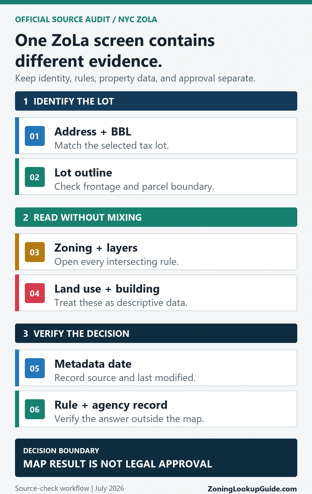
Use the map metadata and the date shown for the relevant dataset, and record the day you performed the search. The ZoLa user guide warns that updates can lag an underlying action and that the city does not guarantee the information for every purpose. Building and property fields can also follow a different update cycle from zoning data.
- Prefer a current live result over an old screenshot or copied listing.
- Record the dataset or field date when the interface provides one.
- Open the linked source when a zoning change, special district, landmark, environmental designation, or other program area affects the decision.
- For a project-specific interpretation, use the city’s planning and application guidance or the responsible agency path.
Save a result another person can reproduce
A useful record explains exactly what was checked. A cropped district label with no parcel identity or date is easy to misread later.
- Official ZoLa URL and the date and time checked.
- Street address plus borough, block, and lot.
- A full view showing the selected lot outline.
- Base district and every displayed overlay, special district, subdistrict, or other zoning designation.
- Relevant data or metadata date.
- Direct links to the current rule text and any amendment or agency record reviewed.
- The actual proposed use or work that still needs interpretation.
ZoLa can create or preserve a link to a map view, but reopen the link before sharing it and confirm that it still selects the same lot and displays the same relevant layers.
When the address, BBL, or layers conflict
Stop and resolve the identity problem before reading more rules. Conflicts often come from an alternate address, a corner entrance, several tax lots, a recent lot change, a split zoning boundary, or an older saved map.
- Search the BBL instead of the street address and compare the highlighted outline.
- Check each lot separately when the property includes more than one BBL.
- Zoom in far enough for scale-dependent layers and labels to appear.
- Open any map-amendment or zoning-history link attached to the result.
- Use zoning change and variance records when the current map does not explain a prior approval or unusual condition.
- Ask the responsible city office to identify the controlling source when the map and record still disagree.
What a ZoLa result does not prove
- That an existing use or occupancy is lawful.
- That permits, certificates, violations, or enforcement matters are clear.
- That a variance, special permit, authorization, or zoning change applies to the proposed work.
- That landmark, environmental, waterfront, building-code, or other agency requirements are satisfied.
- That a development-rights calculation or professional interpretation is correct.
- That the city has approved a purchase, lease, design, filing, or construction project.
Use Zoning Code vs Zoning Map when you need to separate the mapped district from the written rule, and Zoning Lookup by Address for the general jurisdiction-first process outside New York City.
Questions that matter before a property decision
Is ZoLa the official NYC zoning map?
ZoLa is the Department of City Planning’s public zoning and land-use GIS application. It is the correct city map starting point, while the current Zoning Resolution and responsible agencies control the rule and project-specific interpretation.
How do I find a special-purpose district in ZoLa?
Search the address or BBL, select the correct lot, and read the zoning result plus the available zoning layers. Record every special-purpose district or subdistrict shown and open its linked rule text. If several values appear, investigate whether a boundary crosses the lot.
Does the land-use field show what is legally allowed?
No. Land-use and building fields are descriptive property data. They do not replace the mapped zoning, current rule text, certificate of occupancy, permit history, or an agency interpretation.
How current is a ZoLa result?
Check the live interface, the metadata or dataset date, and the date you searched. Do not assume that an old screenshot reflects a later zoning action or property update.
Can I rely on a ZoLa screenshot for a purchase or project?
A screenshot can document what the map displayed on a particular date, but it is not a zoning certification or approval. Preserve the BBL, layers, source links, and rule text so the result can be checked again.
What if one property uses several tax lots?
Search and record each relevant BBL. Do not apply the zoning result from one highlighted lot to an adjoining lot without checking it separately.
Sources checked: NYC ZoLa, the ZoLa User Guide, the ZoLa FAQ, and the NYC Zoning Resolution. Last checked July 28, 2026. Zoning Lookup Guide is an independent routing and interpretation guide, not a New York City agency.