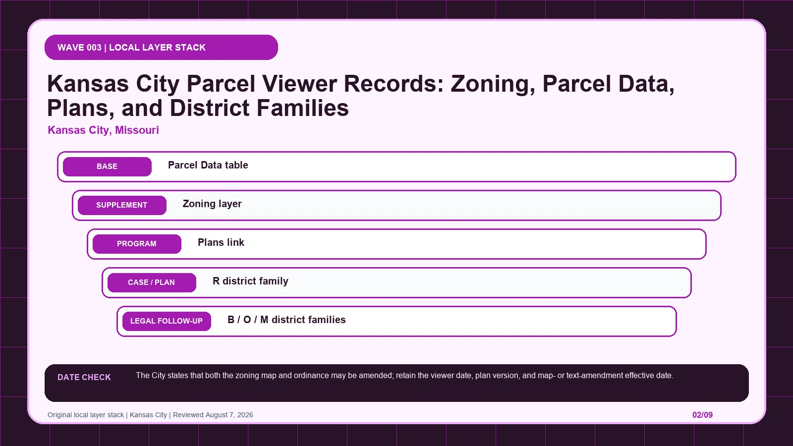
Kansas City’s Parcel Data table locates the land, but an R, B, O, or M family alone does not complete the lookup. UR and MPD results require the Plans link, while map and text amendments must be matched to the instrument that actually became effective. It is not an approval.
Last checked: August 7, 2026.
Begin the parcel-table-to-approved-plan route at Kansas City Development Process Guide, which supplies official parcel-viewer and zoning workflow. Cross-check the selected geometry through KCMO Parcel Viewer, the route used for address, parcel, zoning, and plan lookup. Before copying Parcel Data table, verify kcmo.gov Development Process Guide and guide names Parcel Data and Zoning layer; those markers keep the Development Process Guide tied to the intended jurisdiction and record period.
Parcel Data is the entry point, not the Kansas City zoning answer
Kansas City's Parcel Viewer divides identification, classification, and plan review among visible controls. The Parcel Data table appears after address selection and supplies parcel-specific attributes. The Zoning layer draws the official district polygon and provides the acronym that controls the next lookup. R, B, O, and M prefixes identify district families, but the full acronym and suffix must be preserved because intensity varies within a family. UR and MPD are different: their permitted-use answer depends on the approved development plan reached through the Plans link. The official guide also distinguishes a map amendment, which changes mapped geography, from a text amendment, which changes ordinance language. Parcel Data and the Zoning layer route the inquiry; the exact ordinance or approved plan supplies the operative answer. A pending rezoning belongs in a case column until an effective action changes the map.
Follow an R, B, O, or M family to the provision that defines it
- Open the Development Process Guide; fix the parcel, boundary, jurisdiction, and official key before reading thematic records.
- Start the parcel-table-to-approved-plan route by copying Parcel Data table exactly as returned, including displayed on the left side of Parcel Viewer.
- Keep Zoning layer in a second Development Process Guide worksheet field because it draws official zoning districts.
- Test Plans link independently, then mark its value, service layer, or documented blank in the parcel-table-to-approved-plan route.
- Give R district family and every later item a separate row; never compress history, plans, and overlays into the Development Process Guide result.
- Attach the Development Process Guide lookup time to Parcel Data table, while preserving this separate currency clue: The City states that both the zoning map and ordinance may be amended; retain the viewer date, plan version, and map- or text-amendment effective date.
- If Parcel Data table and Zoning layer conflict, send the parcel-table-to-approved-plan route to Kansas City Development Process Guide and ask whether a district family requires a separately approved plan.
The Development Process Guide worksheet is complete only when another reader can reproduce the parcel-table-to-approved-plan route from the same parcel key and official pages. Keep each source's legal role and effective date apart, then record whether a district family requires a separately approved plan as unresolved instead of selecting the most convenient output. The local currency note remains part of that audit trail: The City states that both the zoning map and ordinance may be amended; retain the viewer date, plan version, and map- or text-amendment effective date.
UR and MPD require a plan link beyond the district family
The Development Process Guide table keeps each returned label beside its displayed scope and the separate legal record still waiting to be opened. Its first checkpoint is Parcel Data table, which may appear as displayed on the left side of Parcel Viewer; from there, Use it to lock the parcel and copy the zoning acronym. A blank in the parcel-table-to-approved-plan route stays visible so another reader can distinguish an empty official return from an unexamined field.
| Local field, layer, or record | What it does | Displayed value or scope | Next code or record check | Official page |
|---|---|---|---|---|
| Parcel Data table viewer record | returns parcel-specific attributes after address selection | displayed on the left side of Parcel Viewer | Use it to lock the parcel and copy the zoning acronym. | Open exact record |
| Zoning layer layer | draws official zoning districts | enabled from Layers > Zoning | Confirm the parcel polygon and district acronym before opening regulations. | Open exact record |
| Plans link viewer record | opens an approved development plan when available | Plans appears under Parcel Data for relevant properties | Required for UR and MPD districts; the acronym alone is incomplete. | Open exact record |
| R district family district family | identifies residential zoning | acronyms beginning with R | Open the exact residential district, not merely the family description. | Open exact record |
| B / O / M district families district families | distinguish business, office, and manufacturing districts | B, O, and M prefixes | Preserve the complete acronym and suffix because intensity varies within a family. | Open exact record |
| UR / MPD plan-dependent districts | requires the approved development plan to determine uses | UR Urban Redevelopment; MPD Master Planned Development | Retrieve the plan through Parcel Viewer and review later amendments. | Open exact record |
| Map amendment / text amendment record distinction | separates parcel-boundary changes from ordinance-language changes | official guide uses both terms | Check which action occurred and its effective date. | Open exact record |
| Returned local record | Record to compare | When to stop | Next decision |
|---|---|---|---|
| Parcel Data table returns displayed on the left side of Parcel Viewer | Compare with Zoning layer, which draws official zoning districts | Stop the parcel-table-to-approved-plan route if Zoning layer is missing, dated differently, or points to another record. | Continue through the Development Process Guide: Use it to lock the parcel and copy the zoning acronym. Then test whether Zoning layer changes that route. |
| Zoning layer returns enabled from Layers > Zoning | Compare with Plans link, which opens an approved development plan when available | Stop the parcel-table-to-approved-plan route if Plans link is missing, dated differently, or points to another record. | Continue through the Development Process Guide: Confirm the parcel polygon and district acronym before opening regulations. Then test whether Plans link changes that route. |
| Plans link returns Plans appears under Parcel Data for relevant properties | Compare with R district family, which identifies residential zoning | Stop the parcel-table-to-approved-plan route if R district family is missing, dated differently, or points to another record. | Continue through the Development Process Guide: Required for UR and MPD districts; the acronym alone is incomplete. Then test whether R district family changes that route. |
| R district family returns acronyms beginning with R | Compare with B / O / M district families, which distinguish business, office, and manufacturing districts | Stop the parcel-table-to-approved-plan route if B / O / M district families is missing, dated differently, or points to another record. | Continue through the Development Process Guide: Open the exact residential district, not merely the family description. Then test whether B / O / M district families changes that route. |
| B / O / M district families returns B, O, and M prefixes | Compare with UR / MPD, which requires the approved development plan to determine uses | Stop the parcel-table-to-approved-plan route if UR / MPD is missing, dated differently, or points to another record. | Continue through the Development Process Guide: Preserve the complete acronym and suffix because intensity varies within a family. Then test whether UR / MPD changes that route. |
| UR / MPD returns UR Urban Redevelopment; MPD Master Planned Development | Compare with Map amendment / text amendment, which separates parcel-boundary changes from ordinance-language changes | Stop the parcel-table-to-approved-plan route if Map amendment / text amendment is missing, dated differently, or points to another record. | Continue through the Development Process Guide: Retrieve the plan through Parcel Viewer and review later amendments. Then test whether Map amendment / text amendment changes that route. |
| Map amendment / text amendment returns official guide uses both terms | Compare with Parcel Data table, which returns parcel-specific attributes after address selection | Stop the parcel-table-to-approved-plan route if Parcel Data table is missing, dated differently, or points to another record. | Continue through the Development Process Guide: Check which action occurred and its effective date. Then test whether Parcel Data table changes that route. |
A parcel with a base family and a separately linked development plan
Consider a hypothetical Kansas City parcel for which the Parcel Data table returns an MPD acronym and displays a Plans link. The researcher first confirms the parcel polygon with the enabled Zoning layer, then opens the linked approved development plan. MPD is expanded as Master Planned Development, but that expansion is not used as a list of allowed uses. The plan and later amendments are reviewed for the parcel-specific answer. If a separate record mentions a text amendment, the researcher checks whether ordinance language changed without assuming that this parcel was rezoned. If a pending map amendment or rezoning also appears, the current acronym remains in the zoning column until the final action and effective date are confirmed. This hypothetical makes the Plans link the decisive bridge between a mapped MPD label and its actual regulations.
Map amendments and text amendments change different parts of the record
Kansas City, Missouri date check: The City states that both the zoning map and ordinance may be amended; retain the viewer date, plan version, and map- or text-amendment effective date.
The Kansas City Development Process Guide documents the official Parcel Viewer and zoning workflow, KCMO Parcel Viewer supplies address, parcel, zoning, and plan lookup, and the City's zoning page supplies the ordinance and planning guidance. The City warns that both the zoning map and ordinance may be amended, so preserve the viewer date, approved-plan version, and effective date of each map or text amendment. These clocks answer different questions. A current plan link can lead to an older approved plan; a new text amendment can affect many districts without moving a parcel boundary; a map amendment can change a parcel while leaving the general text intact. For UR and MPD, save the plan and later amendments as part of the legal scope. Do not let a live viewer timestamp replace the effective record that established the displayed acronym.
| Local situation | What went wrong | What to retain | How to resolve it |
|---|---|---|---|
| Scenario 1 | An MPD acronym is used to answer permitted uses without opening the Plans link. | Preserve Plans link, the selected geometry, and both timestamps from the Development Process Guide check. | Use Kansas City Development Process Guide to settle whether a district family requires a separately approved plan; then Required for UR and MPD districts; the acronym alone is incomplete. |
| Scenario 2 | A text amendment is mistaken for a parcel rezoning, or a pending rezoning is treated as a changed map. | Preserve R district family, the selected geometry, and both timestamps from the Development Process Guide check. | Use Kansas City Development Process Guide to settle whether a district family requires a separately approved plan; then Open the exact residential district, not merely the family description. |
If an MPD acronym was used to answer permitted uses without opening Plans, return to the Parcel Data table, open the link, and attach the approved plan and amendments. If a text amendment was mistaken for a parcel rezoning, identify whether the action changed ordinance language or mapped geography and preserve its effective date. A pending rezoning stays separate from current zoning until a final effective action is documented. The narrow Planning question should quote the full parcel acronym: For this parcel, which current Zoning-layer designation applies, which approved UR or MPD plan and version controls, and did the cited action amend the map, the text, or neither for this property? Include the Parcel Viewer date, Plans link, and action date. That package lets Kansas City resolve the actual source role instead of being asked for a broad approval.
The Development Process Guide and Parcel Viewer divide the work
| Official page | What to check there | Local coverage shown |
|---|---|---|
| Kansas City Development Process Guide | official parcel-viewer and zoning workflow | City page documents the exact map controls and district families |
| KCMO Parcel Viewer | address, parcel, zoning, and plan lookup | City-owned maps.kcmo.org application |
| Kansas City zoning | ordinance and planning guidance | Official City Planning and Development page |
How should Parcel Data table be checked in Kansas City, Missouri?
Open the official Parcel Data table record and capture the value inside the Development Process Guide. That record shows how Parcel Data table returns parcel-specific attributes after address selection; one displayed form is displayed on the left side of Parcel Viewer. Place the copied value in the parcel-table-to-approved-plan route, then follow its separate rule route: Use it to lock the parcel and copy the zoning acronym.
How should Zoning layer be checked in Kansas City, Missouri?
Open the official Zoning layer record and capture the value inside the Development Process Guide. That record shows how Zoning layer draws official zoning districts; one displayed form is enabled from Layers > Zoning. Place the copied value in the parcel-table-to-approved-plan route, then follow its separate rule route: Confirm the parcel polygon and district acronym before opening regulations.
How should Plans link be checked in Kansas City, Missouri?
Open the official Plans link record and capture the value inside the Development Process Guide. That record shows how Plans link opens an approved development plan when available; one displayed form is Plans appears under Parcel Data for relevant properties. Place the copied value in the parcel-table-to-approved-plan route, then follow its separate rule route: Required for UR and MPD districts; the acronym alone is incomplete.
What to send Development Services when the plan link is missing
- Selected parcel key, geometry, and responsible jurisdiction
- Every returned value from the local field table
- Page titles, URLs, lookup times, and update clues
- Opened code, plan, case, ordinance, or metadata records
- Unresolved blanks, boundary splits, dates, and competing outputs
- Proposed activity stated in code-relevant facts
- Agency contact, narrow question, reply date, and limits
The Development Process Guide does not decide title, survey boundaries, private restrictions, vested rights, building-code compliance, utilities, licensing, or permit issuance. Request a written response when the parcel-table-to-approved-plan route leaves competing official results or when substantial reliance is planned. A useful request to Kansas City Development Process Guide identifies the parcel, quotes Parcel Data table and Zoning layer, gives their source dates, and asks whether a district family requires a separately approved plan.
Use kansas city mo zoning map by address, zoning code vs zoning map, zoning overlays special districts only where those methods clarify the parcel-table-to-approved-plan route. The Development Process Guide evidence linked for Parcel Data table and Zoning layer remains the local starting point.
Reviewed August 7, 2026. Recheck the Development Process Guide, its cited ordinance, and the agency procedure before relying on the saved worksheet.