Quick answer: Search the official Chicago zoning map by the complete address, confirm the highlighted parcel and PIN, and record the base district plus any overlay or planned-development reference. Then open the current zoning ordinance for the proposed use or dimensional question.
Move from Chicago address to district, then to code
- Check that the point falls on the intended parcel rather than the street or adjacent lot.
- Keep the full district label and any PD, POS, downtown, or overlay reference visible.
- Cross-check recent ordinances or map amendments when the effective date could change the result.
What this result does not prove
A map district is not a permit, certificate of occupancy, legal-use determination, or complete development analysis.
Verify the live rule at City of Chicago zoning map. Then continue with the parcel-number zoning lookup guide for the next step.
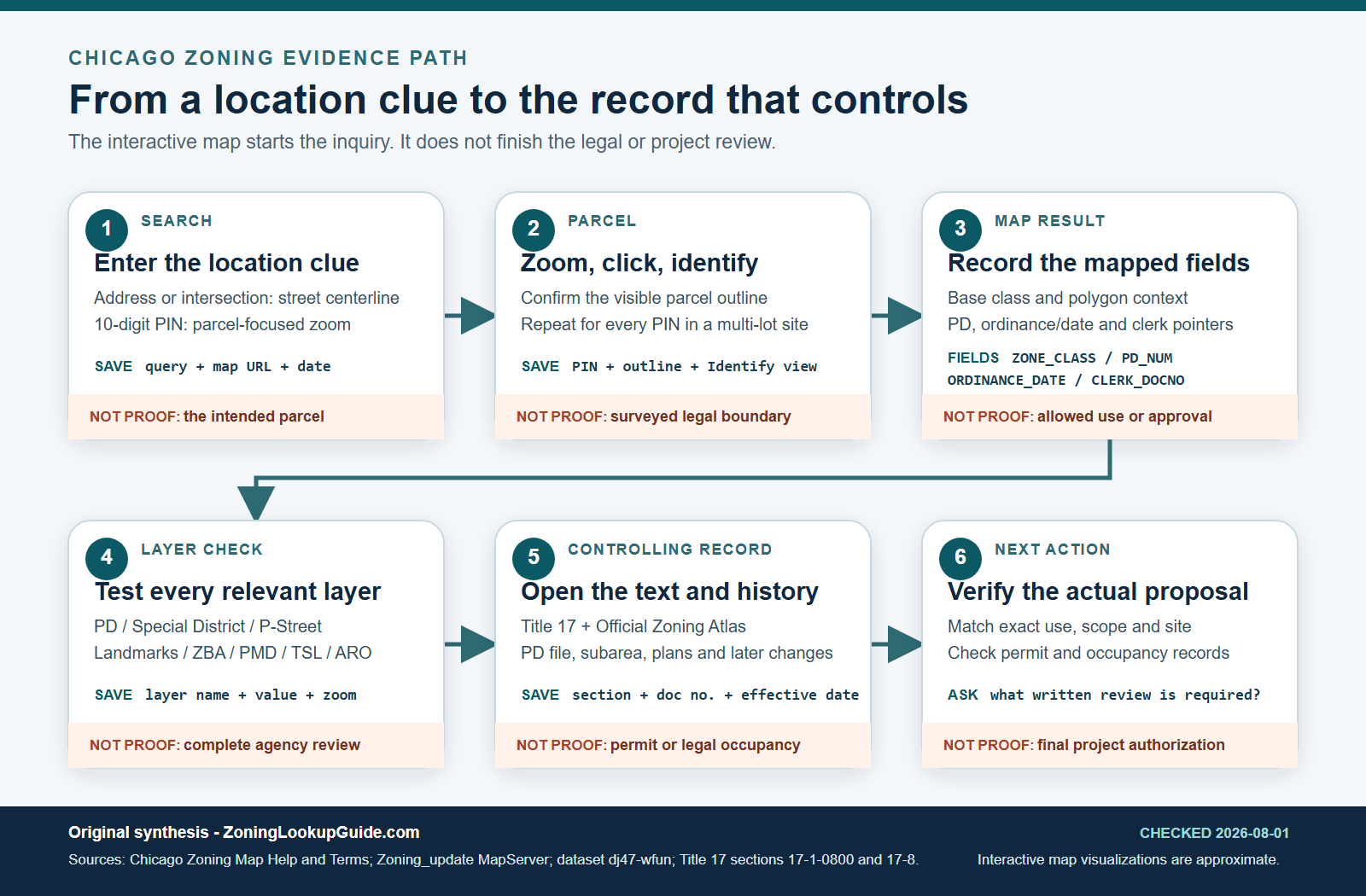
Use the official Chicago Zoning and Land Use Map to check zoning by address. Search the address, intersection, or 10-digit Property Identification Number (PIN), zoom to parcel level, click the intended parcel, and record the full zoning class plus any planned development or other layer. An address result may point to the street rather than the parcel, and the map is a research tool—not project approval.
For a result you can verify later, keep the address, PIN, selected parcel outline, zoning class, layer names, map date, and links to the controlling ordinance in one file. The City of Chicago also publishes a current zoning-district boundaries dataset, but the interactive map is the practical starting point for one property.
What each Chicago zoning result can show
A Chicago zoning lookup is a chain of evidence, not a one-screen answer. An address or intersection only locates the street; a PIN narrows the search to a parcel; the parcel result supplies mapped fields and layers; and those fields point to the current ordinance, official atlas, legislative file, or permit record that must be checked next. The matrix below keeps each result within that scope.
| Stage and input | Evidence boundary and next check |
|---|---|
| Location search – address Street address (example format: 121 N LaSalle St) | Official result: The map zooms to the street centerline near the address Can support: A reproducible starting location for the search Does not prove: That the marker is on the intended parcel; parcel identity; zoning classification Save: Exact query, map URL, search date Next: Zoom to parcel scale and click the intended parcel with Identify · Official source 1 |
| Location search – intersection Street names joined with an ampersand or the advanced intersection search | Official result: The map zooms to the street centerline at the crossing Can support: The correct crossing and a shortlist of corner parcels Does not prove: Which corner parcel is intended; a parcel PIN; zoning classification Save: Both street names, intended corner, map URL, search date Next: Choose the correct corner, zoom in, and click that parcel · Official source 1 |
| Parcel search – PIN 10-digit Property Identification Number, with or without hyphens | Official result: The map zooms to the parcel associated with the entered PIN Can support: A more parcel-specific lookup target than an address or intersection result Does not prove: That one PIN covers the full project site; legal title; a surveyed legal boundary Save: PIN, visible parcel outline, adjoining PINs when the site spans lots Next: Use Identify on the parcel and repeat for every PIN in a multi-lot site · Official source 1 |
| Parcel confirmation Clicked location and Identify result | Official result: Detailed mapped information for the clicked location at the current zoom Can support: That the zoning result was read from the intended mapped land rather than a nearby color or address point Does not prove: That the displayed outline is a surveyed legal boundary Save: Screenshot or print view showing parcel context, PIN, zoom, and date Next: If parcel or boundary remains uncertain, verify against the responsible parcel or official record before reading the district · Official source 1 |
| Base zoning ZONE_CLASS plus zoning polygon or boundary | Official result: The mapped zoning classification and geometry returned by the current public layer Can support: That the selected public polygon carries a mapped classification Does not prove: That a proposed use, density, height, sign, parking plan, or design is allowed; project approval Save: Full class code, polygon context, layer name, query date Next: Open the matching chapters and use tables in current Title 17; check every applicable special rule · Official source 1 |
| Planned development PD_NUM, ZONE_CLASS, ORDINANCE_NUM, ORDINANCE_DATE, CLERK_DOCNO, CLERK_URL when populated | Official result: A mapped PD identifier and available links or identifiers for adopted or related legislative material Can support: A repeatable route from the mapped PD row to available legislative pointers Does not prove: That the first document found is the operative version for the relevant subarea; that all amendments or minor changes are captured Save: PD number, subarea, document number, ordinance date, clerk link, later amendments or changes Next: Open the PD file and legislative record; compare statements, permitted uses, bulk table, boundary or subarea maps, plans, and later changes · Official source 1 |
| Other mapped controls Planned Developments; Lakefront; Pedestrian Street; landmarks or historic; Special District; PMD SubArea; ZBA; ADU; TSL; ARO and other listed layers | Official result: Publicly enumerated map layers that may intersect the location at the selected scale Can support: A repeatable layer inventory for the selected map location Does not prove: That every applicable rule, approval, pending matter, permit condition, or agency record appears in one map Save: Names and values of every relevant visible or intersecting layer, zoom level, query date Next: Open the controlling text or responsible agency record for each material layer · Official source 1 |
| Dates and legislative pointers EDIT_DATE, ORDINANCE_DATE, CLERK_DOCNO and CLERK_URL when present | Official result: When the public row was edited and which legislative identifiers or links the row exposes Can support: A reproducible date and document-pointer record from the public dataset Does not prove: That EDIT_DATE is an ordinance effective date; that a blank field means no governing document; that the record is complete today Save: Dataset checked date, row edit date, ordinance date, clerk document number and URL Next: Compare the map or data row with the current code, official atlas, clerk matter, and any later action · Official source 1 |
| Controlling zoning source Title 17 and Official Zoning Atlas | Official result: The ordinance provisions and adopted map framework that govern the classification question Can support: The controlling source route for a mapped classification or boundary issue Does not prove: A building permit, certificate of occupancy, business license, variance status, or project-specific approval Save: Exact section, atlas or map reference, access date, disputed boundary issue Next: For a classification dispute, use the Official Zoning Atlas maintained by the Zoning Administrator; for a proposal, continue through the applicable review or approval path · Official source 1 |
| Permit and occupancy follow-through Chicago building permit and inspection records plus other responsible agency records | Official result: Public permit or inspection history that may be relevant after the zoning screen Can support: A reproducible public history search tied to the address or record identifier Does not prove: That issued work was performed or code-compliant; that no listed violation means current compliance; legal occupancy or licensing approval Save: Permit number, inspection date or status, certificate or occupancy record, agency response Next: Verify the exact project or use with the Department of Buildings, DPD, licensing, landmarks, fire, or other responsible office as applicable · Official source 1 |
Download: Chicago zoning evidence matrix (CSV). The downloadable file includes row-level source IDs, checked dates, derivation notes, and a separate next action for each result.
What the public zoning layer contained on August 1, 2026
This is a fixed snapshot calculated from City of Chicago public data, not a live counter. Its unit is a zoning polygon record. It must not be cited as a count of parcels, properties, buildings, unique planned developments, approvals, or legal rights.
| Public-data result | Correct reading and limit |
|---|---|
| Rows in current zoning-district dataset 14,920 · zoning polygon records | Correct reading: Count of rows returned by count(*) in dataset dj47-wfun Do not infer: Parcel count, property count, building count, or number of legal zoning districts Official source 1 |
| Rows with non-zero PD_NUM 1,456 (9.8%) · zoning polygon records | Correct reading: Rows whose public PD_NUM field is greater than zero; 9.8% of M1 after rounding Do not infer: Number of unique planned developments, affected parcels, or currently operative PD ordinances Official source 1 |
| Rows with non-null ORDINANCE_ 7,332 (49.1%) · zoning polygon records | Correct reading: Rows whose public ordinance field is populated; 49.1% of M1 after rounding Do not infer: Proof that a blank row has no governing ordinance or that a populated row is the latest complete record Official source 1 |
| Latest row-level EDIT_DATE July 23, 2026 · latest row-level edit date | Correct reading: Maximum EDIT_DATE returned by the dataset at check time Do not infer: The legal effective date of every polygon or the date of the most recent City Council action Official source 1 |
| Public map-service sublayers 22 · enumerated map-service sublayers | Correct reading: Count of child layers numbered 1 through 22 in the official Zoning_update MapServer Do not infer: Twenty-two independent legal approvals or a complete checklist for every project Official source 1 |
Download: Chicago zoning public-data snapshot (CSV). Keep the checked date with any quotation because the public layer can change.
Method: Counts were calculated through the public SoQL endpoint and rounded to one decimal place only where a percentage is shown. Field names were verified against dataset dj47-wfun and the official ArcGIS layers. The table joins those identifiers to Chicago map Help, map Terms, Title 17, the Official Zoning Atlas route, PD or legislative records, and building-record follow-through. A populated field is treated as a pointer to investigate, not as a legal conclusion. This method, the row-level sources, the checked date, and the interpretation limits are preserved in the Chicago zoning evidence matrix above.
City data-use notice: This site provides applications using data that has been modified for use from its original source, www.cityofchicago.org, the official website of the City of Chicago. The City of Chicago makes no claims as to the content, accuracy, timeliness, or completeness of any of the data provided at this site. The data provided at this site is subject to change at any time. It is understood that the data provided at this site is being used at one’s own risk. See the City of Chicago Data Terms of Use.
Choose the search that identifies the right parcel
The map accepts an address, an intersection, or a PIN. Chicago’s map help explains that address and intersection searches center on the street, while a 10-digit PIN search centers on the parcel. That difference matters at corner lots, campuses, shopping centers, condominiums, and sites made up of several tax parcels.
| What you have | What the map does | What you must confirm |
|---|---|---|
| Street address | Centers near the address on the street | Zoom in and click the intended parcel, not the marker |
| Intersection | Centers at the crossing | Select the parcel on the correct corner |
| 10-digit PIN | Centers on the tax parcel | Match the outline and address to the property being reviewed |
| Several PINs | Shows one searched parcel at a time | Repeat the check for every parcel in the site |
If you do not know the PIN, use the address to orient yourself, then compare the selected parcel with the property or tax record you already have. The parcel number zoning lookup guide explains why a property identifier is safer than relying on a business name or mailing label.
Open the map and identify the parcel
- Open the official map and accept the city’s terms if prompted.
- Search the address, intersection, or 10-digit PIN. A PIN can be entered with or without hyphens.
- Zoom until individual parcels and the information needed for the site appear.
- Use the Identify tool on the intended parcel and compare its outline with the property.
- Record the full zoning class and every relevant layer or property-specific reference.
- Repeat the process for adjoining PINs when the property or proposed project spans more than one parcel.
Do not copy a district from the opposite side of the street or from a nearby parcel. If the search marker, parcel outline, address, and PIN do not agree, stop before interpreting the code.
Read the district without dropping another rule layer
The district label is an index to the zoning ordinance, not a complete property decision. Chicago’s public map service includes planned developments, special districts, pedestrian streets, landmark and historic boundaries, planned manufacturing subareas, Zoning Board of Appeals information, and other layers. The city’s zoning map-service directory shows the available layer structure.
| Map item | What to save | What to open next |
|---|---|---|
| Base zoning class | Full letters and numbers exactly as displayed | The current Title 17 district and use rules |
| Planned Development (PD) | PD number and the parcel or subarea involved | Statements, use and bulk tables, plans, and later amendments |
| Special district or subarea | District name and any subarea label | The district chapter and property-specific provisions |
| Pedestrian street or other mapped control | Layer name and where it intersects the parcel | The ordinance section that gives the layer legal effect |
| Historic or landmark layer | Boundary and designation shown | The responsible preservation record and review path |
| Zoning case or appeal reference | Case number, status, and date | The actual decision, conditions, plans, and any later action |
Turn on only the layers that help answer the property question, but make a deliberate pass through the zoning-related layers before you finish. The zoning overlays and special districts guide provides a general layer checklist; the Chicago map remains the source for the parcel itself.
If the result says PD, open the planned-development file
A PD number means the shorthand on the map is not enough. Open the planned-development document and identify the portion of the property covered by the question. Read the statements, permitted uses, bulk table, boundary and property-line map, subarea map, site plan, and conditions. The current codified Chapter 17-8 is the Chicago Zoning Ordinance chapter for planned developments.
- Match the PD number to the selected parcel.
- Identify the applicable subarea instead of applying one table to the entire PD.
- Check for amendments, minor changes, administrative adjustments, and later approvals.
- Read the status, effective date, conditions, expiration language, and approved plans.
- Do not treat the existence of a PDF as proof that a different proposal is allowed today.
If an earlier approval or zoning change is central to the question, organize the record with the zoning change and variance records guide and keep later decisions with the original ordinance.
When the address, PIN, and parcel do not agree
A no-result screen or mismatched outline does not prove that the property has no zoning. Retry the search before drawing any conclusion.
- Remove a unit number and search the building’s base street address.
- Check street direction, spelling, and suffix, then try the nearest intersection.
- Use the 10-digit PIN if the address centers on the wrong part of the street.
- For a corner or multi-lot site, search every known PIN separately.
- Compare the outline with an official tax or property record and keep notes on any mismatch.
- If a district boundary appears to cross the parcel, save the view and ask the responsible city office how the boundary should be verified.
Move from the map label to the rule that controls
After recording the district and layers, open the current Chicago Zoning Ordinance and Land Use Ordinance. Follow the district, use table, standards, measurements, exceptions, footnotes, and any property-specific document identified by the map. The hosted code includes a publisher disclaimer, so confirm critical questions with the municipality and the appropriate official process.
State the real question before reading: the existing use, proposed business, conversion, addition, new building, sign, parking arrangement, or other work. The zoning code versus zoning map guide explains why the district color alone cannot answer that question. For a business use, continue to the commercial property zoning check.
Save a result another person can verify
- Official map URL and the date checked.
- Street address and 10-digit PIN.
- A view that shows the selected parcel outline.
- Full zoning class and every relevant layer.
- PD number, subarea, ordinance, amendments, and plans when applicable.
- Case numbers, decision dates, status, and conditions.
- The exact proposed use or work that still needs interpretation.
Reopen saved links before relying on them. Map layers, documents, and ordinances can change, and a screenshot without the PIN, selected parcel, and date is difficult to reproduce.
What the Chicago zoning map does not prove
The map does not prove that an existing use was legally established, that a proposed use is allowed, that a variance or PD approval remains effective, or that a building can be occupied or altered as proposed. It does not replace a survey, title review, permit and inspection history, building or fire review, business licensing, landmark approval, or a written city determination. Chicago’s map terms also state that map visualizations are approximate and should not substitute for professional or official advice.
When money or construction depends on the answer, give the responsible city office the PIN, parcel, full zoning result, relevant documents, and a precise description of the proposal. Ask which written confirmation or application process fits that question.
Questions people ask after opening the map
Why did the address search place the result in the street?
The city’s help page says address and intersection searches center on the street. Zoom to parcel level, use Identify on the intended property, or search with the 10-digit PIN.
Is the PIN the same as the zoning district?
No. The PIN identifies a tax parcel. The zoning map then shows the district and other mapped controls associated with the selected location.
What if one address covers several PINs?
Search every relevant PIN and keep the results together. Do not apply the zoning or planned-development subarea from one selected parcel to an adjoining parcel without checking it separately.
Does a PD number tell me what I can build?
Not by itself. Match the parcel to the correct PD and subarea, then read the statements, use and bulk tables, plans, conditions, amendments, and later decisions that apply to the proposal.
Official Chicago map, help, terms, map-service, open-data, and code sources were checked August 1, 2026. Zoning Lookup Guide is an independent routing and interpretation guide, not a City of Chicago agency.