In the United States, a zoning lookup by address starts with the official city, town, or county planning map; there is no single national parcel-zoning database. Confirm the jurisdiction and parcel identifier, record the base district and every overlay, then open the current ordinance and property-specific case history. A map color or district code is not permission to build, occupy, or operate a particular use.
The useful result is not just “R-3” or “C2.” It is a short evidence file that ties the right parcel to the map date, district, overlays, ordinance sections, variances or conditions, and the exact activity you are considering. That file gives a local planner or qualified professional something specific to verify.
Reviewed August 1, 2026. This is a research workflow, not a zoning determination or legal advice. Local maps, codes, procedures, and record names differ.
Find the government that controls the parcel
Zoning authority is local. A mailing address can name a city even when the parcel is outside that city’s limits, and an unincorporated property may be regulated by the county. Some regions also divide planning, zoning, building, historic-preservation, and environmental records among separate offices.
- Start with the city or county website, not a real-estate listing or a map aggregator.
- Look for a planning, zoning, community development, GIS, assessor, or parcel-map page on the official government domain.
- If the boundary is unclear, use the USA.gov local-government directory and then confirm jurisdiction with the relevant local office.
- Record the government name and the map or database title. Two agencies can publish different layers for the same address.
The site’s zoning official-sources directory is a routing aid when you know the place but not the agency. It does not replace the agency’s current map or code.
Confirm the parcel, not just the street address
An address is a search term; the assessor parcel, tax lot, PIN, APN, or borough-block-lot is the record identifier. Corner buildings can use more than one address, one project can cross several parcels, and the same street address can exist in different municipalities or boroughs.
- Enter the complete address, including city and state, in the official local map.
- Choose the result in the correct jurisdiction, borough, ward, or county.
- Match the parcel number and visible boundary to the property you intend to check.
- Look for multiple lots, condominium units, corner addresses, split zoning, or a pin that falls on the neighboring parcel.
- Save the parcel identifier, map link, result date, and a printable record or screenshot when the official tool permits it.
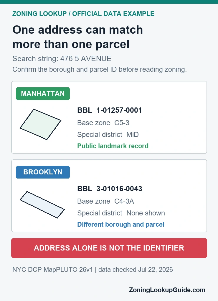
The real-data example below comes from NYC Department of City Planning MapPLUTO. The same search string, 476 5 AVENUE, returns one record in Manhattan and another in Brooklyn. The borough and borough-block-lot separate the intended public-landmark parcel from the unrelated parcel. Use the parcel-number zoning lookup guide when an address result is incomplete or ambiguous.
Read the map as an evidence chain
A zoning map is an index to other records. Read each field for the question it can answer, then keep moving until the proposed use and property history have been checked.
| Evidence | What to record | What it still does not answer |
|---|---|---|
| Jurisdiction | City, town, county, planning authority, and official source | Which exact parcel the address belongs to |
| Parcel | APN, PIN, lot, BBL, boundary, and address match | What the zoning rules allow |
| Map layers | Base district, overlays, special districts, split-zone lines, and map date | How the ordinance applies to the proposed activity |
| Ordinance | Definitions, use table, dimensional rules, procedures, and effective date | Whether a parcel-specific decision changes the general rule |
| Property history | Variances, conditional uses, planned developments, conditions, and pending cases | Whether a new permit or approval will be issued |
| Written answer | The office, question, documents supplied, response, and date | Professional due diligence outside that response’s scope |
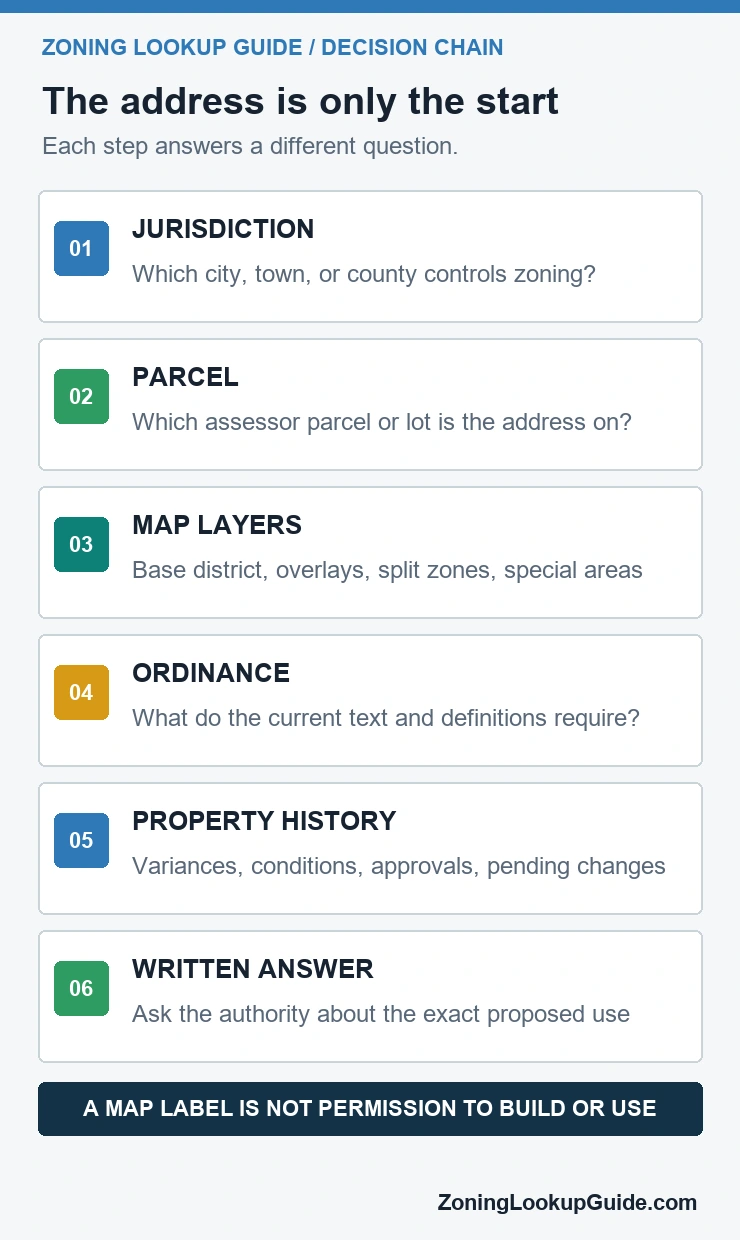
Do not merge these layers into one conclusion. A parcel can be correctly mapped while a listing quotes an obsolete district. A base district can be current while an overlay, planned development, or prior condition changes the practical answer. The GIS zoning map guide explains why the visible layer, legend, metadata, and update date belong together.
Open the ordinance behind the district code
A district label points to a chapter, table, or set of rules. It does not summarize permitted and conditional uses, lot dimensions, setbacks, height, floor area, parking, signs, accessory uses, home occupations, or review procedures. Open the code version linked by the local planning authority and read the definitions before relying on familiar words.
- Check whether the proposed activity is permitted by right, conditional, accessory, temporary, prohibited, or not listed.
- Follow every cross-reference from the district table to use-specific and site-specific standards.
- Read measurement definitions before calculating setbacks, height, floor area, lot coverage, parking, or density.
- Check the adoption and effective dates when a map or code amendment is recent.
See zoning code versus zoning map for the distinction between the mapped classification and the controlling text, and zoning district meaning for a cautious way to read district abbreviations without assuming that similar labels mean the same thing in another city.
Check what happened to this property
General zoning rules are only part of a parcel review. Search the local case, hearing, permit, and ordinance systems for decisions tied to the parcel or project. A variance may authorize a narrow departure with conditions. A planned development or special permit may replace part of the base-district analysis. A lawful nonconforming use may depend on history that a map does not show.
- Variances, conditional-use or special-use approvals, and their conditions
- Planned developments, site plans, development agreements, and recorded exhibits
- Rezoning ordinances, map amendments, pending applications, and hearing dates
- Nonconforming-use or noncomplying-structure records where the jurisdiction maintains them
- Historic, design-review, environmental, coastal, or other controls maintained outside the zoning map
The zoning change and variance records guide focuses on finding the final decision and its conditions. A violation or code-enforcement record is different from a zoning entitlement; use the zoning violations and code-enforcement guide when the question concerns enforcement history.
Ask the planning office a question it can answer
“What can I do here?” is too broad for a reliable first inquiry. Describe the exact use or project and show the records already found. For example: “For parcel 123-456-789 in District C-2 with Overlay H, may a 1,200-square-foot ground-floor bakery with on-site seating be reviewed as a permitted use, or is a conditional-use process required?”
- Provide the full address, parcel identifier, municipality, district, overlays, and map date.
- State the proposed use, floor area, occupancy, physical work, hours, parking, or other facts that matter.
- Cite the ordinance sections and property cases that created the uncertainty.
- Ask what written zoning-verification, interpretation, clearance, pre-application, or formal-determination process the jurisdiction offers.
- Record who responded, the date, the documents reviewed, and the limits of the answer.
An informal phone call may help you find the next office, but it may not be binding or sufficient for a purchase, lease, financing, permit, or enforcement question. The planning-department zoning search guide helps organize a request before contacting staff.
What an address lookup cannot prove
- That the current or proposed use is lawful
- That a permit, variance, conditional use, rezoning, or certificate will be approved
- That a building’s existing occupancy matches the zoning and building records
- That the parcel is free of private covenants, easements, title issues, environmental limits, or lender restrictions
- That every map layer or property case is current, complete, and correctly interpreted
For a purchase decision, use the land-use map check before buying to separate current land use, future land-use policy, and zoning. Commercial users should also review the commercial property zoning check before signing a lease or relying on a broker’s description.
Official tools show why local context matters
New York City: ZoLa and BBL
NYC ZoLa uses the borough-block-lot alongside the address and displays zoning and land-use context. NYC311’s planning page says ZoLa zoning information is updated monthly and directs specific zoning questions to the Zoning Information Desk. The MapPLUTO example in this article was independently rendered from the NYC DCP MapPLUTO service; NYC Open Data states that its data has no restrictions on use. For a city-specific workflow, see the site’s NYC ZoLa official-source guide.
Chicago: address, PIN, or intersection
The Chicago Zoning and Land Use Map accepts an address, 10-digit Property Identification Number, or intersection. Its official help page explains that more parcel detail appears as the map is enlarged, while the map terms say visualizations are approximate and are not a substitute for professional advice. Use the Chicago map-by-address guide for the city-specific search sequence.
Los Angeles: ZIMAS and multiple planning layers
Los Angeles City Planning describes ZIMAS as a property-specific tool searchable by address, intersection, assessor parcel number, case number, and other local identifiers. The city also tells users to review overlays and links them to the code that applies to the relevant plan area. The site’s Los Angeles ZIMAS guide follows those layers without treating the first zone label as the answer.
After you identify the base zone, check for zoning overlays and special districts that may add design review, environmental limits, use conditions, or area-specific standards.
If the address search fails or returns the wrong parcel
A blank result is not proof that the property has no zoning. It usually means the search string, parcel record, jurisdiction, or public interface needs another check. Stop before borrowing a nearby parcel’s district: adjacent lots can have different base zones, overlays, case histories, or municipal authorities.
| Problem | Try next | Do not conclude |
|---|---|---|
| No address match | Remove the unit, spell out or abbreviate the street suffix, try the former street name, and search the assessor or parcel system. | That no official record exists. |
| Several matches | Compare municipality, ZIP code, parcel identifier, legal description, and visible boundary. | That the first result is the intended property. |
| Pin falls beside the building | Click the parcel polygon and compare its outline with the assessor map or survey. | That the map marker defines the legal parcel. |
| New lot or recent replat | Search the parent parcel, plat name, subdivision case, and newly assigned identifier; ask when the zoning layer will reflect the change. | That a missing new identifier removes existing rules. |
| Parcel crosses a line | Record both sides of the apparent boundary and ask the authority whether the line is precise enough for the proposed work. | That the whole parcel follows the easier classification. |
| Portal shows no conventional zone | Confirm whether the jurisdiction uses another system, county controls, development regulations, private restrictions, or a special district. | That the property is unrestricted. |
When the parcel number on the planning map differs from the assessor, deed, survey, or title material, write down every identifier rather than choosing one silently. Ask the planning or GIS office which layer is authoritative for zoning and which office maintains parcel geometry. A tax parcel, zoning lot, legal lot, condominium unit, and development site can describe different units of land.
Separate current zoning from plans, permits, and private restrictions
A search can return several records that look similar but answer different questions. Current zoning regulates under the jurisdiction’s adopted rules. A comprehensive or future land-use plan usually guides later policy and does not by itself replace the current zoning map. A permit approves specified work or use under stated conditions. A private covenant can restrict property even when the public zoning map does not show it.
| Record | Question it answers | Common mistake |
|---|---|---|
| Current zoning map and code | What public zoning classification and general rules are in force now? | Reporting a map color without the current code or overlays. |
| Comprehensive or future land-use plan | What policy designation or long-range direction applies? | Calling the plan designation the parcel’s current zone. |
| Variance, special use, planned development, or condition | Has a site-specific decision changed or supplemented the general rule? | Assuming the base district tells the complete story. |
| Building, occupancy, or business permit | Was a defined activity or construction scope approved? | Treating the zoning label as the permit itself. |
| Deed restriction, covenant, or easement | Does a private recorded instrument limit use, setbacks, structures, or access? | Assuming the public zoning portal searches title records. |
For due diligence, label each saved item with its source and date: map observation, adopted rule, policy plan, case decision, permit record, or private instrument. That prevents a broker description, future-plan designation, and legally effective zoning classification from being copied into one unsupported conclusion. The land-use map guide for buyers explains the current-versus-future distinction in more detail.
When “no zoning” is the correct local answer
Some jurisdictions do not use a conventional citywide zoning ordinance. That is a real result, but it does not end an address check. Houston, Texas, for example, states that it has no citywide comprehensive zoning ordinance while applying development regulations, special land-use controls in limited areas, subdivision and site-plan rules, and separately filed restrictions. Use the dedicated Houston no-zoning address check to confirm city limits or ETJ, review Chapter 42 and mapped development layers, check airport or St. George Place exceptions, and research recorded deed restrictions.
The broader rule is simple: report what the responsible authority actually calls its system. Do not invent a zoning district when none exists, and do not translate “no comprehensive zoning” into “no rules.” The evidence file should identify the applicable public regulations and private records instead of forcing every location into the same map-and-district template.
Questions to settle before money changes hands
Is there one national zoning lookup by address?
No. U.S. zoning is administered locally. National directories can route you to a government, but the city, town, county, or other local authority maintains the controlling map, code, and procedures.
Can I rely on the zoning shown in a property listing?
Use it only as a lead. Confirm the parcel and current district on the official local source, then check overlays, ordinance text, and property-specific decisions.
Why might the map and code appear to disagree?
The map and code answer different parts of the question, or one source may have a different effective date. Also check overlays, split zoning, planned developments, variances, and recent amendments before assuming an error.
What should I do when a property covers more than one parcel?
Record and check every parcel separately. Do not assume one district, overlay, approval, or condition applies across the entire site, and ask the planning authority how the proposed project is reviewed across parcel boundaries.
A zoning map by address, USA, or “near me” search still ends at a local authority
There is no single zoning map for every U.S. address. Search wording such as zoning map USA or zoning near me is only a discovery step. The answer must come from the city, town, county, parish, borough, or other planning authority that controls the parcel. Use the exact address to identify that jurisdiction, then repeat the search with the parcel number when the map boundary or address match is uncertain.
| Search phrase | What it should lead to | Evidence to save | What it cannot prove |
|---|---|---|---|
| Zoning map by address | The responsible local government’s official parcel or zoning map | Entered address, selected parcel, district code, overlays, map date, and source URL | That the map selected the intended legal parcel or allows a proposed project |
| Zoning map USA | A route to the correct state and local planning authority, not a national zoning answer | State, municipality or county, official map owner, and ordinance link | That one nationwide directory contains current local rules |
| Zoning near me | The authority for the property’s exact location, including unincorporated areas | Full address, jurisdiction boundary, parcel ID, and planning-office contact | That phone location or postal city identifies the zoning authority |
| Zoning check | The current district plus overlays, ordinance, property cases, and later approvals | Every controlling layer and the dated record checked next | Permission to build, occupy, license, or operate a use |
If the local map and parcel record disagree, stop at the mismatch. Save both results and ask the planning office which parcel, map edition, overlay, and ordinance section control. A map lookup is an evidence route, not an approval or legal determination.