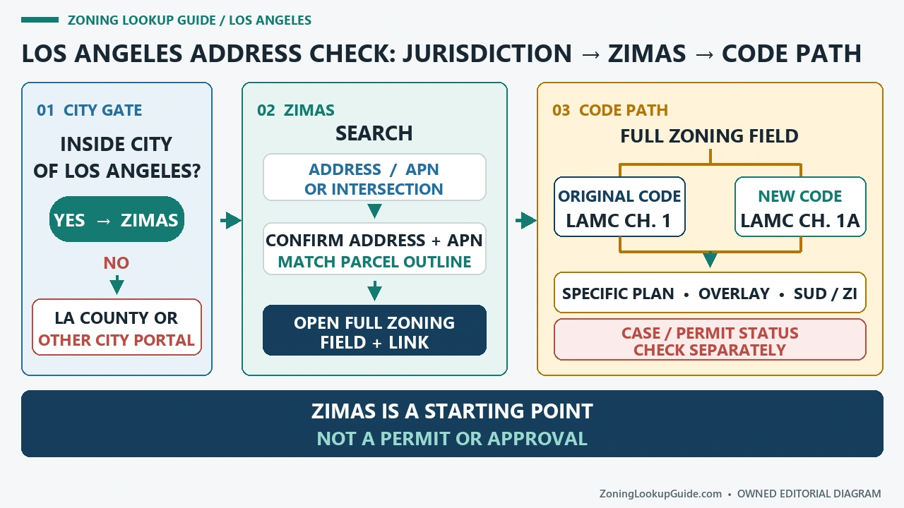
A Los Angeles ZIMAS result is useful only after two questions are settled: is the parcel inside the City of Los Angeles, and which zoning code does the property record say applies? Open the City Planning Zoning Search page for the live ZIMAS route. A Los Angeles mailing address can still be outside city jurisdiction, and a familiar zone-looking string should not be decoded before the applicable-code branch is recorded.
Reviewed August 26, 2026 against the live City Planning and County jurisdiction routes cited below.
Make jurisdiction the first branch, not the last caveat
Start with the exact site address and assessor parcel number. If ZIMAS returns a City parcel, keep the site address, APN, Community Plan Area, and Council District together. If it returns nothing or the boundary is uncertain, do not substitute a nearby parcel. Check the jurisdiction and move an unincorporated parcel to the county system.
| Observed condition | Next authority | Evidence to retain |
|---|---|---|
| ZIMAS identifies a City parcel | City ZIMAS | Site address, APN, plan area, displayed zone, applicable code |
| The location is unincorporated | LA County Regional Planning | County parcel identity and county zoning result |
| City boundary remains unclear | Pause the zoning interpretation | Screenshot of the failed query and the parcel/jurisdiction question sent to staff |
Choose the search key that can identify one parcel
ZIMAS accepts more than a street address. City Planning lists property address, street intersection, assessor parcel number, case number, Community Plan Area, Council District, Certified Neighborhood Council, PIN number, legal description, and MapSheet. Those inputs do different jobs. An address or intersection finds an area; an APN is stronger for selecting one tax parcel; a case number opens a planning record rather than proving the current parcel zone.
- Enter the complete address, including direction and street type, and select the returned candidate rather than relying on the map pin alone.
- Compare the ZIMAS site address and APN with the source document used for the transaction or project.
- If an address covers several lots, repeat the lookup for every APN and record the result in separate rows.
- Save the Community Plan Area because it helps determine the controlling planning framework and where a later update belongs.
Read the ZIMAS report as a stack of records
The first useful output is parcel identity, not a permitted-use conclusion. Capture the site address, APN, lot or tract identifiers, and jurisdictional entries. Then move to Planning and Zoning and transcribe the full zone string exactly. Keep General Plan land use, specific-plan or overlay references, zoning-information files, ordinances, and case numbers in their own columns. A linked case may impose conditions, but its presence alone does not tell you that a proposed use is approved.
| ZIMAS record family | Copy now | Do not infer |
|---|---|---|
| Assessor and parcel | APN, lot, tract, calculated area | That the mapped shape resolves a survey or title boundary |
| Planning and Zoning | Full zone string, applicable code, plan land use | That the base zone is the only rule layer |
| Special controls | Specific plan, HPOZ, CDO, ZI file, ordinance | That a link is irrelevant because the project seems small |
| Cases and permits | Case number, status/date, linked record | That a filed or historical case grants a current entitlement |
Keep ZIMAS search keys, zoning layers, and linked records separate
A ZIMAS result becomes useful only when the parcel identity stays attached to every zoning layer and linked record. Save the address, APN, PIN, full zoning designation, planning geography, overlays, cases, and lookup date as separate fields. That makes the result reproducible and prevents a base-zone label from being mistaken for the complete rule set.
| ZIMAS field group | What to save and what it does not prove |
|---|---|
| Address or intersection | Use these to find the location, then confirm the highlighted parcel. The City Planning zoning-search page lists the accepted search routes. A location match alone does not prove the parcel, jurisdiction, or allowed use. |
| APN, PIN, legal description, MapSheet | Keep the parcel identifiers and cadastral reference together. The official ZIMAS brochure distinguishes Book-Page-Parcel, Parcel Identification, Tract-Block-Lot, and MapSheet. None is a permit or survey. |
| Community Plan, Council District, Neighborhood Council | These identify planning and civic geographies. They help route the next source, but none is a substitute for the property’s zoning designation. |
| Full zoning and General Plan Land Use | Record them as different fields. Follow the property-specific code link and confirm whether Chapter 1 or Chapter 1A applies using the city’s current zoning rules and code-applicability guidance. |
| Overlays, historic review, RSO | Open each listed source instead of treating the indicator as a complete answer. These layers can trigger separate rules or agencies; a flag by itself does not approve, prohibit, exempt, or certify a proposal. |
| Case numbers | Open the case file and read status, decision, conditions, amendments, effective date, and later action. The existence of a case does not prove current approval or transferability. |
| Building Permit Info | Follow the permit and code-enforcement links to the responsible department. The brochure says ZIMAS permit history goes back only to the mid-1990s, so it is not a complete substitute for the current permit record. |
| Lookup date and saved report | Save the report and date used. ZIMAS is a centralized reference point, not a permit, boundary certification, or written planning determination. |
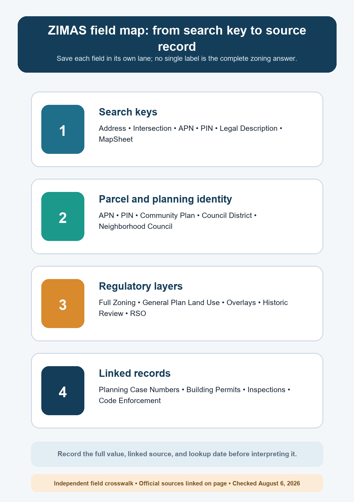
Method: We normalized the search inputs and report fields named in the City Planning zoning-search materials and ZIMAS brochure, then attached a cross-check and interpretation limit to every row. Open the official ZIMAS application for the live property result. Last checked August 6, 2026; review after interface, zoning-code, community-plan, or linked-record changes.
Scope: This is an independent routing and interpretation asset. It does not certify a boundary, approve a use or project, replace a survey or title review, or provide a written planning determination.
Let the Applicable Code field decide the code route
City Planning maintains both the Original Zoning Code, Chapter 1 and the New Zoning Code, Chapter 1A. Chapter 1 remains the zoning regulation route for areas where the new code has not become applicable; Chapter 1A applies in the areas brought into the new framework and also contains citywide processes and procedures. Do not choose between them from memory or from a neighborhood name. Record the applicable-code indication for the exact parcel, then open that code.
A zone string is an index into the rules. It is not a stand-alone answer about use, height, yards, parking, density, or an entitlement condition.
Resolve blank results and conflicting Los Angeles records
- No parcel appears: remove unit information, retry the root address, then search the APN. Preserve the exact failed query.
- The pin lands on a street: select the parcel polygon and verify its APN before reading zoning.
- Several parcels share one address: make one evidence row per APN; never average their zoning strings.
- City and county sources disagree: stop and confirm jurisdiction before comparing the zoning labels.
- A code link and a case document appear inconsistent: compare effective dates and ask City Planning which record controls the proposed action.
Finish with a parcel-specific decision packet
Keep the ZIMAS checked date, inputs, selected APN, full zoning string, applicable code, General Plan designation, every listed overlay or special plan, and unresolved case condition. Use Zoning Code vs Zoning Map when moving from the label to regulations, Parcel Number Zoning Lookup when one address contains several lots, and Zoning Overlays and Special Districts for the additional-rule layer. The final status should be one of three bounded outcomes: parcel and code route matched; jurisdiction unresolved; or staff confirmation required.