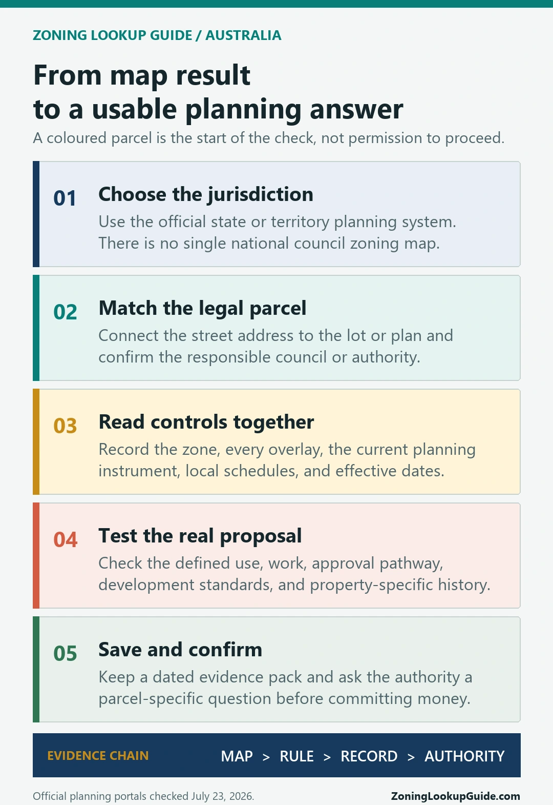
Australia does not have one national council zoning map. The reliable starting point is the official planning map for the state or territory where the land sits. Use it to match the street address to the legal parcel, identify the zone and every applicable overlay, then open the planning scheme or Territory Plan provisions linked to those results. Confirm the current position with the responsible council or planning authority before relying on the map for a purchase, lease, design, or development application.
A map colour alone does not answer whether a proposed use is permitted. The useful answer combines the right parcel, the current zone, overlay controls, definitions, use and development tables, local schedules or policies, and any property-specific approval or amendment. This guide gives you a repeatable route through that evidence without pretending the viewer itself grants approval.
Official entry points and instructions were checked on July 23, 2026. Planning schemes, map layers, council boundaries, and amendments change, so record the date of every search and reopen the live source before acting.
Start with the state or territory, not a national map
Planning systems in Australia are administered through states and territories, with local government responsibilities varying by jurisdiction. That is why a search for an “Australia council zoning map” cannot end at one national portal. First establish whether the property is in New South Wales, Victoria, Queensland, South Australia, Western Australia, Tasmania, the Australian Capital Territory, or the Northern Territory.
Then use the official viewer or planning-scheme path for that jurisdiction. In Queensland, for example, the state explains that every parcel is zoned but each local government regulates development through its local planning scheme. The state’s mapping of state interests is useful additional evidence, not a replacement for the local scheme. In the ACT, the Territory Plan and its district and zone policies form the controlling framework rather than a municipal zoning ordinance.
- Confirm the state or territory and the responsible local council or planning authority.
- Open that jurisdiction’s official property planning viewer or planning scheme.
- Search the address, then verify the legal parcel before reading any coloured layer.
- Record the zone, overlays, applicable planning instrument, and the date checked.
- Test the actual proposed use or work against the written provisions and local guidance.
Match the address to the legal parcel and planning authority
An address is a search key, not always the legal unit controlled by the planning scheme. Apartment complexes, corner properties, rural holdings, newly subdivided land, and sites with several street numbers can return more than one parcel. Check the lot and plan, deposited plan, volume and folio, title reference, or equivalent parcel identifier displayed by the official system.
The NSW Planning Portal Spatial Viewer illustrates the point well. Its result panel connects a searched address to a Lot/Section/Plan number and names the council. The same result can expose separate Land Zoning, Height of Buildings, Floor Space Ratio, environmental, development control, and contributions material. That is much more useful than copying a zone colour from a general web map.
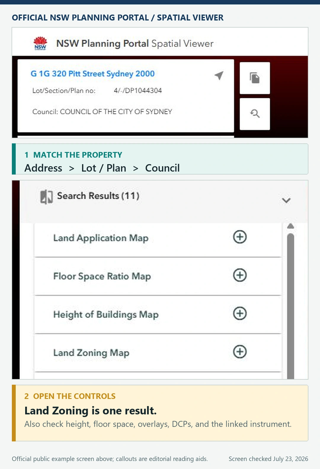
Compare the highlighted boundary with the building footprint, road frontage, and neighbouring lots. If it looks wrong, stop and resolve the parcel first. Our parcel-number zoning lookup guide explains why this identity check belongs before interpretation, while the zoning lookup by address guide covers the broader address-to-record workflow.
Read the zone, overlays, and planning instrument together
The base zone is only the first index into the rules. Open the layer details and record the exact zone code and name. Then check every overlay or mapped constraint returned for the parcel, including heritage, flooding, bushfire, coastal risk, airport or noise controls, biodiversity, acid sulfate soils, height, floor-space ratio, design, character, or local provisions where those layers exist.
Next open the current planning instrument behind the map. Read the definition of the proposed use, the table or policy that says whether it is permitted, prohibited, exempt, accepted, assessable, or subject to consent, and the development standards that apply. A home business, secondary dwelling, short-term rental, warehouse, subdivision, sign, or change of use can follow a different pathway on the same parcel.
Do not substitute a legend for the written control. The distinction is covered in our zoning code versus zoning map guide. Keep both pieces of evidence: the map proves which provisions appear to attach to the parcel, while the adopted instrument explains what those provisions mean.
Official planning map entry points across Australia
Use the row that matches the property’s jurisdiction. A state viewer may still direct you to a council scheme, local schedule, development control plan, or planning officer for the complete answer.
| Jurisdiction | Official starting point | What to carry forward |
|---|---|---|
| New South Wales | NSW Planning Portal Spatial Viewer | Lot/plan, council, EPI, zone, overlays, DCP and contributions results |
| Victoria | VicPlan | Parcel, zone and overlay codes, ordinance links, property report |
| Queensland | Local planning scheme directory | Correct council scheme plus relevant state-interest mapping |
| South Australia | SAPPA | Parcel, Planning and Design Code zone, overlays and subzones |
| Western Australia | PlanWA | Parcel and planning layers, then current local scheme and structure plan |
| Tasmania | LISTmap | Planning scheme zones, overlays and authoritative instrument references |
| Australian Capital Territory | ACTmapi | Territory Plan Map, district policy and zone policy |
| Northern Territory | NT planning zones guidance and NT Atlas | Zone, overlays, planning scheme clauses and Development Assessment Services advice |
Victoria says VicPlan can search an address or parcel, display zone and overlay ordinance links, and create a property report. South Australia’s SAPPA instructions similarly direct users to search an address or plan parcel and inspect Planning Zones and Overlays. Western Australia warns that an official title address may differ from a postal address and notes that some earlier structure plans may require confirmation with the local government. Those details are reminders to follow the local workflow instead of forcing every jurisdiction into one template.
What the map can and cannot establish
| The official map can help establish | It does not by itself establish |
|---|---|
| The parcel selected and planning authority shown | That the selected parcel is legally identical to the land in your contract or title |
| The mapped zone and overlays at the time viewed | That every relevant control, amendment, approval, or site condition is visible |
| Links or references to the applicable planning instrument | That a proposed use or design is approved |
| A dated starting point for a council enquiry | A planning certificate, legal opinion, permit, or development consent |
Official portals also publish update and accuracy cautions. The NSW portal tells users to consult the relevant council for the latest information and explains that spatial data can lag the official environmental planning instrument maps. VicPlan is updated on a cycle rather than continuously. PlanWA similarly describes regular updates while directing users to local government for material that may not appear in the viewer. Read the disclaimer and the layer’s effective date whenever the decision is time-sensitive.
If money or a binding commitment depends on the answer, obtain the jurisdiction-specific certificate, written planning advice, or professional review appropriate to that decision. The land-use map check before buying guide sets out the due-diligence boundary in more detail.
Check property history and changes that may not be obvious
A current map cannot tell the whole history of an existing building or activity. Search for development applications, permits, consents, conditions, variations, enforcement records, heritage approvals, and subdivision records available through the council or state system. An activity may be lawful because of an earlier approval, or restricted by conditions that do not appear in the zone label.
Also look for exhibited or adopted amendments, structure plans, precinct plans, and proposed rezoning. Separate what is legally in force today from what is proposed. A planning proposal, draft scheme, or community consultation can be commercially important without yet changing the current legal control.
- Existing use: find the approval and conditions supporting it; do not infer legality from visible occupation.
- New use or work: identify the planning pathway and every standard or referral that could apply.
- Future change: record whether an amendment is merely proposed, adopted but not commenced, or already effective.
Save an evidence pack and ask a precise council question
Keep a small evidence pack so another person can reproduce the check. Save the full address, parcel reference, council or authority, map URL, search date, zone, every overlay, the planning instrument and clause links, property report if offered, relevant application numbers, and a plain description of the proposed use or work. A screenshot is helpful context, but it should sit beside the live links and identifiers rather than replace them.
When contacting the council, avoid asking only, “What can I do here?” A better enquiry is: “For Lot X in Plan Y at this address, the official viewer returned Zone Z and overlays A and B on this date. I propose this specific use and work. Which current planning scheme provisions, approval pathway, and property-specific records should I check?” That gives the officer a parcel, proposal, and evidence trail to correct.
Use the planning department zoning search guide to prepare that enquiry, and the official zoning sources directory when you need to verify whether a search result belongs to the responsible government authority.
Australia zoning map questions
Is there one official zoning map for all of Australia?
No. Start with the official planning system for the state or territory, then follow any local-council scheme, schedule, policy, or development-control material that applies to the parcel.
Does the local council always control zoning?
Not in exactly the same way everywhere. States and territories establish different planning frameworks, and local government roles vary. Use the jurisdiction’s official portal to identify the responsible authority instead of assuming the council name alone answers the question.
Can I rely on the colour shown on the map?
No. Record the zone code, open the linked planning instrument, check overlays and local provisions, and verify the proposed use against the current written rules.
Why does the postal address return the wrong lot?
Postal addresses and legal parcel descriptions can differ, especially for multi-lot, corner, rural, strata, or newly subdivided properties. Search the lot or title reference and compare the mapped boundary before interpreting the result.
Is an official map result the same as planning approval?
No. It is evidence for the next check. Approval depends on the applicable planning instrument, the proposed use and work, property history, other legislation, and the decision of the responsible authority.
Sources and review date
This independent guide was reviewed on July 23, 2026 against official planning information from NSW, Victoria, Queensland, South Australia, Western Australia, Tasmania, the ACT, and the Northern Territory. The linked authority and the current planning instrument control a property-specific answer.